Juncosa geodata
Juncosa (Catalonia) is a seat of a third-order administrative division; located in Spain in Europe/Madrid (GMT+2) time zone. In our database, there are 6762 cities with bigger population. Compared to other cities in Spain, 56.7% of cities are located further ↓South; 89.9% of cities are located further ←West and 55.2% of cities have higher elevation than Juncosa. Note1


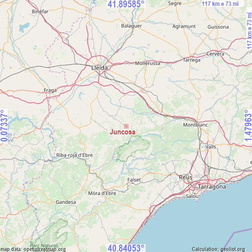
Juncosa GPS coordinates[2]
41° 22' 13.188" North, 0° 46' 35.4" East
| Map corner | latitude | longitude |
|---|---|---|
| Upper-left | 41.89585°, | 0.07337° |
| Center: | 41.37033°, | 0.7765° |
| Lower-right: | 40.84053°, | 1.47963° |
| Map W x H: | 117.3×117.3 km | = 72.9×72.9mi |
| max Lat: | 43.74134° ⇑43.3% North |
| Juncosa: | 41.37033° |
| min Lat: | ⇓56.7% South 27.64134° |
| min Long | Juncosa | max Long |
| -18.00367° | 0.7765° | 4.2899° |
| W 89.9%⇐ | ⇒10.1% E |
Elevation
Elevation of Juncosa is 592 m = 1942 ft, and this is 6 m = 20 ft below average elevation for this country.
| Max E: |
1682 m = 5518 ft | 55.2% |
| Avg. | 598 m = 1962 ft | |
| Juncosa | 592 m = 1942 ft | |
Min E: |
0 m = 0 ft | 44.8% |
See also: Spain elevation on elevation.city.
Geographical zone
Juncosa is located in North temperate zone (between Tropic of Cancer and the Arctic Circle). Distance of this Northern Tropic circle is 1994 km =1239 mi to South.| Distance of | km | miles | from Juncosa |
|---|---|---|---|
| North Pole | 5407.1 | 3359.8 | to North |
| Arctic Circle | 2801.2 | 1740.6 | to North |
| Tropic Cancer | 1994 | 1239 | to South |
| Equator | 4599.9 | 2858.2 | to South |


Nearby cities:
15 places around Juncosa: (largest is in red/bold)
• Alcanó
18.1 km =11.2 mi,  312°
312°
• Aspa
16.3 km =10.1 mi,  327°
327°
• Bovera
12.1 km =7.5 mi,  240°
240°
• Castelldans
14.4 km =8.9 mi,  356°
356°
• Cornudella de Montsant
15.8 km =9.8 mi,  137°
137°
• Margalef
9.7 km =6 mi,  191°
191°
• Prades
18.9 km =11.7 mi,  110°
110°
• Torrebesses
16.3 km =10.1 mi,  295°
295°
• Ulldemolins
9.9 km =6.2 mi,  122°
122°
• Vallclara
17.3 km =10.7 mi,  86°
86°
• Vilanova de Prades
15.2 km =9.4 mi,  99°
99°
• Vinaixa
18.6 km =11.6 mi,  67°
67°
• el Cogul
13.2 km =8.2 mi,  324°
324°
• la Granadella
9.4 km =5.8 mi,  256°
256°
• la Morera de Montsant
12.9 km =8 mi,  155°
155°
Sources, notices
• [Note1] Compared only with cities in Spain existing in our database
• [Src1] Map data: © OpenStreetMap contributors (CC-BY-SA)
• [Src2] Other city data from geonames.org with taken over terms of usage.
• [Src3] Geographical zone / Annual Mean Temperature by Robert A. Rohde @ Wikipedia
