Margalef geodata
Margalef (Catalonia) is a seat of a third-order administrative division; located in Spain in Europe/Madrid (GMT+2) time zone. With population of 128 people, there are 5608 cities with bigger population in this country. Compared to other cities in Spain, 55% of cities are located further ↓South; 89.8% of cities are located further ←West and 69.7% of cities have higher elevation than Margalef. Note1


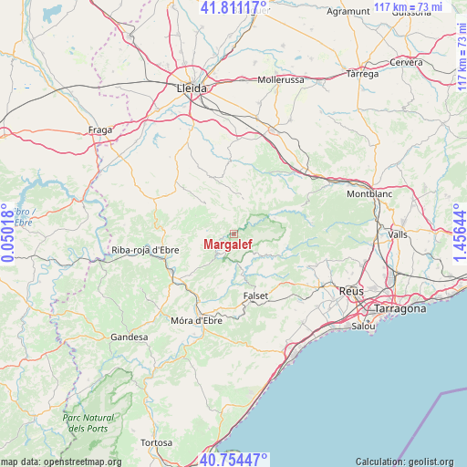
Margalef GPS coordinates[2]
41° 17' 5.856" North, 0° 45' 11.916" East
| Map corner | latitude | longitude |
|---|---|---|
| Upper-left | 41.81117°, | 0.05018° |
| Center: | 41.28496°, | 0.75331° |
| Lower-right: | 40.75447°, | 1.45644° |
| Map W x H: | 117.5×117.5 km | = 73×73mi |
| max Lat: | 43.74134° ⇑45% North |
| Margalef: | 41.28496° |
| min Lat: | ⇓55% South 27.64134° |
| min Long | Margalef | max Long |
| -18.00367° | 0.75331° | 4.2899° |
| W 89.8%⇐ | ⇒10.2% E |
Elevation
Elevation of Margalef is 387 m = 1270 ft, and this is 211 m = 692 ft below average elevation for this country.
| Max E: |
1682 m = 5518 ft | 69.7% |
| Avg. | 598 m = 1962 ft | |
| Margalef | 387 m = 1270 ft | |
Min E: |
0 m = 0 ft | 30.3% |
See also: Spain elevation on elevation.city.
Geographical zone
Margalef is located in North temperate zone (between Tropic of Cancer and the Arctic Circle). Distance of this Northern Tropic circle is 1984.5 km =1233.1 mi to South.| Distance of | km | miles | from Margalef |
|---|---|---|---|
| North Pole | 5416.6 | 3365.7 | to North |
| Arctic Circle | 2810.7 | 1746.5 | to North |
| Tropic Cancer | 1984.5 | 1233.1 | to South |
| Equator | 4590.5 | 2852.4 | to South |


Nearby cities:
15 places around Margalef: (largest is in red/bold)
• Ascó
19.3 km =12 mi,  234°
234°
• Bovera
9.3 km =5.8 mi,  292°
292°
• Cornudella de Montsant
12.9 km =8 mi,  99°
99°
• Falset
16.4 km =10.2 mi,  160°
160°
• Flix
18 km =11.2 mi,  250°
250°
• Garcia
18.9 km =11.7 mi,  207°
207°
• Juncosa
9.7 km =6 mi,  11°
11°
• Llardecáns
19.7 km =12.2 mi,  300°
300°
• Porrera
13.7 km =8.5 mi,  141°
141°
• Ulldemolins
11.1 km =6.9 mi,  68°
68°
• Vilanova de Prades
18.4 km =11.4 mi, 67°
• Vinebre
17.7 km =11 mi, 230°
• el Masroig
16.9 km =10.5 mi,  185°
185°
• la Granadella
10.2 km =6.3 mi,  314°
314°
• la Morera de Montsant
7.7 km =4.8 mi,  106°
106°
Sources, notices
• [Note1] Compared only with cities in Spain existing in our database
• [Src1] Map data: © OpenStreetMap contributors (CC-BY-SA)
• [Src2] Other city data from geonames.org with taken over terms of usage.
• [Src3] Geographical zone / Annual Mean Temperature by Robert A. Rohde @ Wikipedia
