Cornudella de Montsant geodata
Cornudella de Montsant (Catalonia) is a populated place; located in Spain in Europe/Madrid (GMT+2) time zone. With population of 981 people, there are 2977 cities with bigger population in this country. Compared to other cities in Spain, 54.7% of cities are located further ↓South; 90.2% of cities are located further ←West and 58.9% of cities have higher elevation than Cornudella de Montsant. Note1
Administrative division(s):
- Level 1: Catalonia
- Level 2: Província de Barcelona
- Level 3: Castellet i la Gornal
Current local time in Cornudella de Montsant:
09:34 PM, ThursdayDifference from your time zone: hours


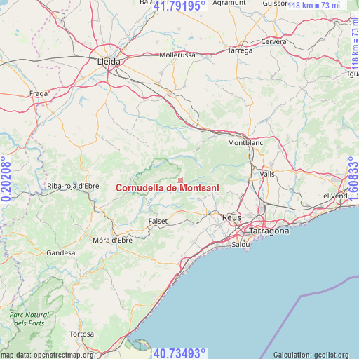
Cornudella de Montsant GPS coordinates[2]
41° 15' 56.088" North, 0° 54' 18.72" East
| Map corner | latitude | longitude |
|---|---|---|
| Upper-left | 41.79195°, | 0.20208° |
| Center: | 41.26558°, | 0.9052° |
| Lower-right: | 40.73493°, | 1.60833° |
| Map W x H: | 117.5×117.5 km | = 73×73mi |
| max Lat: | 43.74134° ⇑45.3% North |
| Cornudella de Montsant: | 41.26558° |
| min Lat: | ⇓54.7% South 27.64134° |
| min Long | Cornudella de M | max Long |
| -18.00367° | 0.9052° | 4.2899° |
| W 90.2%⇐ | ⇒9.8% E |
Elevation
Elevation of Cornudella de Montsant is 542 m = 1778 ft, and this is 56 m = 184 ft below average elevation for this country.
| Max E: |
1682 m = 5518 ft | 58.9% |
| Avg. | 598 m = 1962 ft | |
| Cornudella de Montsant | 542 m = 1778 ft | |
Min E: |
0 m = 0 ft | 41.1% |
See also: Spain elevation on elevation.city.
Geographical zone
Cornudella de Montsant is located in North temperate zone (between Tropic of Cancer and the Arctic Circle). Distance of this Northern Tropic circle is 1982.4 km =1231.8 mi to South.| Distance of | km | miles | from Cornudella de Montsant |
|---|---|---|---|
| North Pole | 5418.8 | 3367.1 | to North |
| Arctic Circle | 2812.9 | 1747.9 | to North |
| Tropic Cancer | 1982.4 | 1231.8 | to South |
| Equator | 4588.3 | 2851 | to South |


Nearby cities:
15 places around Cornudella de Montsant: (largest is in red/bold)
• Alforja
8.4 km =5.2 mi,  135°
135°
• Capafonts
11.4 km =7.1 mi,  70°
70°
• Duesaigües
13.1 km =8.1 mi,  169°
169°
• Falset
15.1 km =9.4 mi,  208°
208°
• Margalef
12.9 km =8 mi,  279°
279°
• Maspujols
14.9 km =9.3 mi,  128°
128°
• Porrera
9.5 km =5.9 mi, 205°
• Prades
8.5 km =5.3 mi,  54°
54°
• Riudecols
12.3 km =7.6 mi,  151°
151°
• Ulldemolins
6.7 km =4.2 mi,  339°
339°
• Vallclara
14.3 km =8.9 mi,  27°
27°
• Vilanova de Prades
10.2 km =6.3 mi,  24°
24°
• Vilaplana
11.5 km =7.1 mi,  111°
111°
• la Morera de Montsant
5.3 km =3.3 mi,  269°
269°
• les Borges del Camp
14.4 km =8.9 mi, 139°
Sources, notices
• [Note1] Compared only with cities in Spain existing in our database
• [Src1] Map data: © OpenStreetMap contributors (CC-BY-SA)
• [Src2] Other city data from geonames.org with taken over terms of usage.
• [Src3] Geographical zone / Annual Mean Temperature by Robert A. Rohde @ Wikipedia
