Prades geodata
Prades (Catalonia) is a seat of a third-order administrative division; located in Spain in Europe/Madrid (GMT+2) time zone. In our database, there are 6762 cities with bigger population. Compared to other cities in Spain, 55.5% of cities are located further ↓South; 90.5% of cities are located further ←West and 85.2% of cities have lower elevation than Prades. Note1


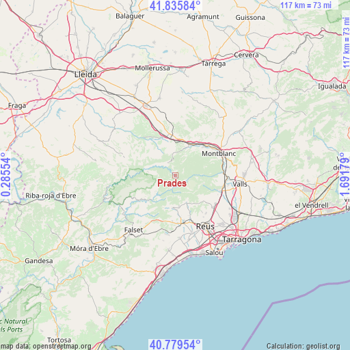
Prades GPS coordinates[2]
41° 18' 35.388" North, 0° 59' 19.176" East
| Map corner | latitude | longitude |
|---|---|---|
| Upper-left | 41.83584°, | 0.28554° |
| Center: | 41.30983°, | 0.98866° |
| Lower-right: | 40.77954°, | 1.69179° |
| Map W x H: | 117.4×117.4 km | = 72.9×72.9mi |
| max Lat: | 43.74134° ⇑44.5% North |
| Prades: | 41.30983° |
| min Lat: | ⇓55.5% South 27.64134° |
| min Long | Prades | max Long |
| -18.00367° | 0.98866° | 4.2899° |
| W 90.5%⇐ | ⇒9.5% E |
Elevation
Elevation of Prades is 953 m = 3127 ft, and this is 355 m = 1165 ft above average elevation for this country.
| Max E: |
1682 m = 5518 ft | 14.8% |
| Prades | 953 m 3127 ft | |
| Avg. | 598 m = 1962 ft | |
Min E: |
0 m = 0 ft | 85.2% |
See also: Spain elevation on elevation.city.
Geographical zone
Prades is located in North temperate zone (between Tropic of Cancer and the Arctic Circle). Distance of this Northern Tropic circle is 1987.3 km =1234.9 mi to South.| Distance of | km | miles | from Prades |
|---|---|---|---|
| North Pole | 5413.8 | 3364 | to North |
| Arctic Circle | 2808 | 1744.8 | to North |
| Tropic Cancer | 1987.3 | 1234.9 | to South |
| Equator | 4593.2 | 2854.1 | to South |


Nearby cities:
15 places around Prades: (largest is in red/bold)
• Alcover
16 km =9.9 mi,  109°
109°
• Alforja
11 km =6.8 mi,  185°
185°
• Capafonts
3.9 km =2.4 mi, 106°
• Cornudella de Montsant
8.5 km =5.3 mi,  234°
234°
• La Riba
15.6 km =9.7 mi,  85°
85°
• Maspujols
15 km =9.3 mi,  161°
161°
• Mont-ral
9.8 km =6.1 mi, 107°
• Riudecols
15.7 km =9.8 mi,  183°
183°
• Ulldemolins
9.5 km =5.9 mi,  278°
278°
• Vallclara
7.8 km =4.8 mi,  356°
356°
• Vilanova de Prades
5.1 km =3.2 mi,  328°
328°
• Vilaplana
9.8 km =6.1 mi, 157°
• Vimbodí
11.3 km =7 mi,  27°
27°
• Vinaixa
13.7 km =8.5 mi, 358°
• la Morera de Montsant
13.2 km =8.2 mi,  248°
248°
Sources, notices
• [Note1] Compared only with cities in Spain existing in our database
• [Src1] Map data: © OpenStreetMap contributors (CC-BY-SA)
• [Src2] Other city data from geonames.org with taken over terms of usage.
• [Src3] Geographical zone / Annual Mean Temperature by Robert A. Rohde @ Wikipedia
