Jarilla geodata
Jarilla (Extremadura) is a seat of a third-order administrative division; located in Spain in Europe/Madrid (GMT+2) time zone. In our database, there are 6762 cities with bigger population. Compared to other cities in Spain, 67.6% of cities are located further ↑North; 86.1% of cities are located further →East and 62.5% of cities have higher elevation than Jarilla. Note1


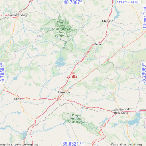
Jarilla GPS coordinates[2]
40° 10' 17.616" North, 6° 0' 10.116" West
| Map corner | latitude | longitude |
|---|---|---|
| Upper-left | 40.7067°, | -6.70594° |
| Center: | 40.17156°, | -6.00281° |
| Lower-right: | 39.63217°, | -5.29969° |
| Map W x H: | 119.5×119.5 km | = 74.3×74.3mi |
| max Lat: | 43.74134° ⇑67.6% North |
| Jarilla: | 40.17156° |
| min Lat: | ⇓32.4% South 27.64134° |
| min Long | Jarilla | max Long |
| -18.00367° | -6.00281° | 4.2899° |
| W 13.9%⇐ | ⇒86.1% E |
Elevation
Elevation of Jarilla is 492 m = 1614 ft, and this is 106 m = 348 ft below average elevation for this country.
| Max E: |
1682 m = 5518 ft | 62.5% |
| Avg. | 598 m = 1962 ft | |
| Jarilla | 492 m = 1614 ft | |
Min E: |
0 m = 0 ft | 37.5% |
See also: Spain elevation on elevation.city.
Geographical zone
Jarilla is located in North temperate zone (between Tropic of Cancer and the Arctic Circle). Distance of this Northern Tropic circle is 1860.7 km =1156.2 mi to South.| Distance of | km | miles | from Jarilla |
|---|---|---|---|
| North Pole | 5540.4 | 3442.6 | to North |
| Arctic Circle | 2934.5 | 1823.4 | to North |
| Tropic Cancer | 1860.7 | 1156.2 | to South |
| Equator | 4466.7 | 2775.5 | to South |


Nearby cities:
15 places around Jarilla: (largest is in red/bold)
• Abadía
10 km =6.2 mi,  12°
12°
• Aldeanueva del Camino
11.6 km =7.2 mi,  32°
32°
• Cabezabellosa
3.8 km =2.4 mi,  177°
177°
• Cabrero
11.4 km =7.1 mi,  124°
124°
• Casas del Castañar
10.9 km =6.8 mi,  130°
130°
• Casas del Monte
5 km =3.1 mi,  44°
44°
• El Torno
6.4 km =4 mi, 128°
• Gargantilla
11 km =6.8 mi, 39°
• Gargüera
13.8 km =8.6 mi,  152°
152°
• Guijo de Granadilla
13.9 km =8.6 mi,  280°
280°
• Oliva de Plasencia
9.7 km =6 mi,  227°
227°
• Segura de Toro
7.5 km =4.7 mi, 38°
• Valdastillas
11.3 km =7 mi,  112°
112°
• Villar de Plasencia
4.3 km =2.7 mi,  209°
209°
• Zarza de Granadilla
8.3 km =5.2 mi,  332°
332°
Sources, notices
• [Note1] Compared only with cities in Spain existing in our database
• [Src1] Map data: © OpenStreetMap contributors (CC-BY-SA)
• [Src2] Other city data from geonames.org with taken over terms of usage.
• [Src3] Geographical zone / Annual Mean Temperature by Robert A. Rohde @ Wikipedia
