Cabrero geodata
Cabrero (Extremadura) is a seat of a third-order administrative division; located in Spain in Europe/Madrid (GMT+2) time zone. With population of 363 people, there are 4269 cities with bigger population in this country. Compared to other cities in Spain, 68.5% of cities are located further ↑North; 84.6% of cities are located further →East and 58.1% of cities have lower elevation than Cabrero. Note1


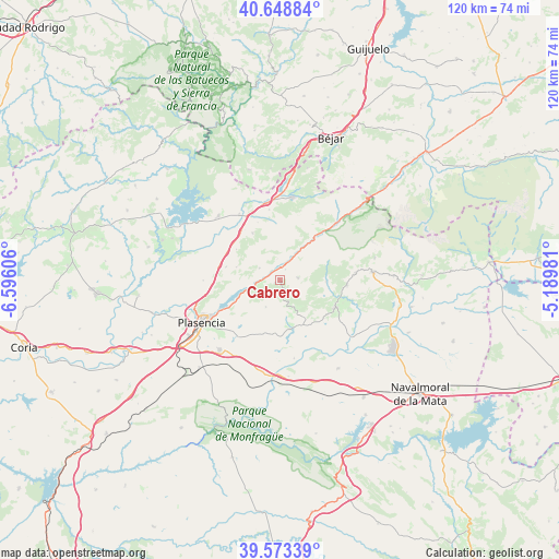
Cabrero GPS coordinates[2]
40° 6' 47.664" North, 5° 53' 34.548" West
| Map corner | latitude | longitude |
|---|---|---|
| Upper-left | 40.64884°, | -6.59606° |
| Center: | 40.11324°, | -5.89293° |
| Lower-right: | 39.57339°, | -5.18981° |
| Map W x H: | 119.6×119.6 km | = 74.3×74.3mi |
| max Lat: | 43.74134° ⇑68.5% North |
| Cabrero: | 40.11324° |
| min Lat: | ⇓31.5% South 27.64134° |
| min Long | Cabrero | max Long |
| -18.00367° | -5.89293° | 4.2899° |
| W 15.4%⇐ | ⇒84.6% E |
Elevation
Elevation of Cabrero is 730 m = 2395 ft, and this is 132 m = 433 ft above average elevation for this country.
| Max E: |
1682 m = 5518 ft | 41.9% |
| Cabrero | 730 m 2395 ft | |
| Avg. | 598 m = 1962 ft | |
Min E: |
0 m = 0 ft | 58.1% |
See also: Spain elevation on elevation.city.
Geographical zone
Cabrero is located in North temperate zone (between Tropic of Cancer and the Arctic Circle). Distance of this Northern Tropic circle is 1854.3 km =1152.2 mi to South.| Distance of | km | miles | from Cabrero |
|---|---|---|---|
| North Pole | 5546.9 | 3446.7 | to North |
| Arctic Circle | 2941 | 1827.5 | to North |
| Tropic Cancer | 1854.3 | 1152.2 | to South |
| Equator | 4460.2 | 2771.4 | to South |


Nearby cities:
15 places around Cabrero: (largest is in red/bold)
• Arroyomolinos de la Vera
7.6 km =4.7 mi,  152°
152°
• Barrado
3.3 km =2.1 mi,  161°
161°
• Cabezabellosa
9.6 km =6 mi,  286°
286°
• Cabezuela del Valle
11.6 km =7.2 mi,  39°
39°
• Casas del Castañar
1.2 km =0.7 mi,  239°
239°
• Casas del Monte
11.6 km =7.2 mi,  329°
329°
• El Torno
5 km =3.1 mi,  300°
300°
• Garganta la Olla
9.9 km =6.2 mi,  91°
91°
• Gargüera
6.5 km =4 mi,  207°
207°
• Jarilla
11.4 km =7.1 mi, 304°
• Navaconcejo
8.8 km =5.5 mi, 36°
• Piornal
3.9 km =2.4 mi,  83°
83°
• Tejeda de Tiétar
10.8 km =6.7 mi,  169°
169°
• Valdastillas
2.5 km =1.6 mi,  27°
27°
• Villar de Plasencia
11.8 km =7.3 mi,  283°
283°
Sources, notices
• [Note1] Compared only with cities in Spain existing in our database
• [Src1] Map data: © OpenStreetMap contributors (CC-BY-SA)
• [Src2] Other city data from geonames.org with taken over terms of usage.
• [Src3] Geographical zone / Annual Mean Temperature by Robert A. Rohde @ Wikipedia
