Coaña geodata
Coaña (Asturias) is a seat of a third-order administrative division; located in Spain in Europe/Madrid (GMT+2) time zone. With population of 3,440 people, there are 1601 cities with bigger population in this country. Compared to other cities in Spain, 99.5% of cities are located further ↓South; 93.2% of cities are located further →East and 89.7% of cities have higher elevation than Coaña. Note1


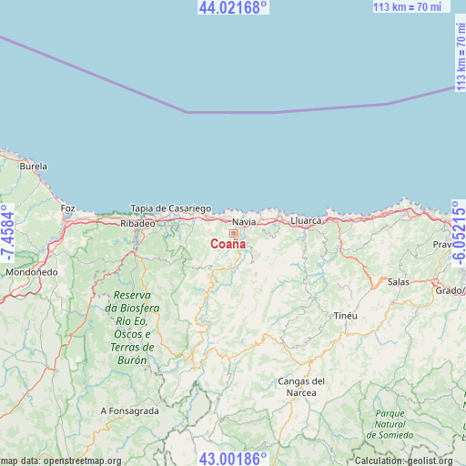
Coaña GPS coordinates[2]
43° 30' 50.112" North, 6° 45' 18.972" West
| Map corner | latitude | longitude |
|---|---|---|
| Upper-left | 44.02168°, | -7.4584° |
| Center: | 43.51392°, | -6.75527° |
| Lower-right: | 43.00186°, | -6.05215° |
| Map W x H: | 113.4×113.4 km | = 70.5×70.5mi |
| max Lat: | 43.74134° ⇑0.5% North |
| Coaña: | 43.51392° |
| min Lat: | ⇓99.5% South 27.64134° |
| min Long | Coaña | max Long |
| -18.00367° | -6.75527° | 4.2899° |
| W 6.8%⇐ | ⇒93.2% E |
Elevation
Elevation of Coaña is 71 m = 233 ft, and this is 527 m = 1729 ft below average elevation for this country.
| Max E: |
1682 m = 5518 ft | 89.7% |
| Avg. | 598 m = 1962 ft | |
| Coaña | 71 m = 233 ft | |
Min E: |
0 m = 0 ft | 10.3% |
See also: Spain elevation on elevation.city.
Geographical zone
Coaña is located in North temperate zone (between Tropic of Cancer and the Arctic Circle). Distance of this Northern Tropic circle is 2232.4 km =1387.1 mi to South.| Distance of | km | miles | from Coaña |
|---|---|---|---|
| North Pole | 5168.8 | 3211.7 | to North |
| Arctic Circle | 2562.9 | 1592.5 | to North |
| Tropic Cancer | 2232.4 | 1387.1 | to South |
| Equator | 4838.3 | 3006.4 | to South |


Nearby cities:
15 places around Coaña: (largest is in red/bold)
• Boal
10.3 km =6.4 mi,  207°
207°
• Castropol
22.2 km =13.8 mi,  273°
273°
• El Franco
10.1 km =6.3 mi,  297°
297°
• Figueras
22 km =13.7 mi,  277°
277°
• Illano
21.9 km =13.6 mi,  203°
203°
• Navia
3.8 km =2.4 mi,  50°
50°
• Pesoz
30.7 km =19.1 mi, 197°
• Pola de Allande
28.9 km =18 mi,  158°
158°
• Ribadeo
23.2 km =14.4 mi, 276°
• San Martín de Oscos
32.3 km =20.1 mi, 211°
• Tapia de Casariego
16.4 km =10.2 mi,  292°
292°
• Vegadeo
24.6 km =15.3 mi,  258°
258°
• Vilaión
8.3 km =5.2 mi,  150°
150°
• Villanueva de Oscos
29.2 km =18.1 mi,  219°
219°
• Villapedre
9.3 km =5.8 mi,  67°
67°
Sources, notices
• [Note1] Compared only with cities in Spain existing in our database
• [Src1] Map data: © OpenStreetMap contributors (CC-BY-SA)
• [Src2] Other city data from geonames.org with taken over terms of usage.
• [Src3] Geographical zone / Annual Mean Temperature by Robert A. Rohde @ Wikipedia
