El Franco geodata
El Franco (Asturias) is a populated place; located in Spain in Europe/Madrid (GMT+2) time zone. With population of 4,071 people, there are 1461 cities with bigger population in this country. Compared to other cities in Spain, 99.8% of cities are located further ↓South; 93.8% of cities are located further →East and 90.8% of cities have higher elevation than El Franco. Note1


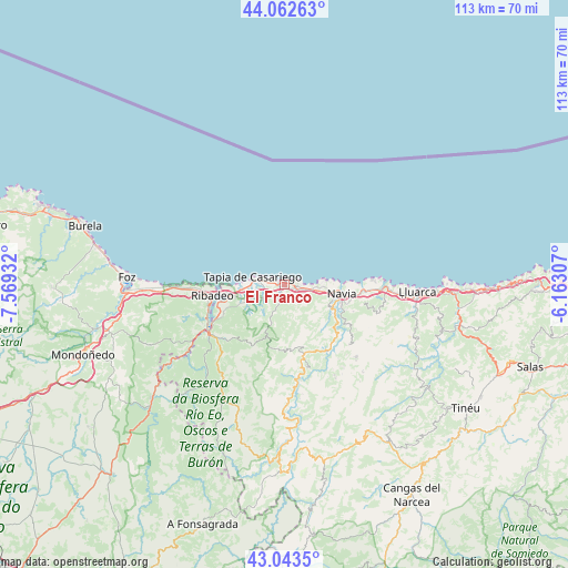
El Franco GPS coordinates[2]
43° 33' 18.792" North, 6° 51' 58.32" West
| Map corner | latitude | longitude |
|---|---|---|
| Upper-left | 44.06263°, | -7.56932° |
| Center: | 43.55522°, | -6.8662° |
| Lower-right: | 43.0435°, | -6.16307° |
| Map W x H: | 113.3×113.3 km | = 70.4×70.4mi |
| max Lat: | 43.74134° ⇑0.2% North |
| El Franco: | 43.55522° |
| min Lat: | ⇓99.8% South 27.64134° |
| min Long | El Franco | max Long |
| -18.00367° | -6.8662° | 4.2899° |
| W 6.2%⇐ | ⇒93.8% E |
Elevation
Elevation of El Franco is 54 m = 177 ft, and this is 544 m = 1785 ft below average elevation for this country.
| Max E: |
1682 m = 5518 ft | 90.8% |
| Avg. | 598 m = 1962 ft | |
| El Franco | 54 m = 177 ft | |
Min E: |
0 m = 0 ft | 9.2% |
See also: Spain elevation on elevation.city.
Geographical zone
El Franco is located in North temperate zone (between Tropic of Cancer and the Arctic Circle). Distance of this Northern Tropic circle is 2237 km =1390 mi to South.| Distance of | km | miles | from El Franco |
|---|---|---|---|
| North Pole | 5164.2 | 3208.9 | to North |
| Arctic Circle | 2558.3 | 1589.7 | to North |
| Tropic Cancer | 2237 | 1390 | to South |
| Equator | 4842.9 | 3009.2 | to South |


Nearby cities:
15 places around El Franco: (largest is in red/bold)
• Boal
14.3 km =8.9 mi,  163°
163°
• Castropol
13.6 km =8.5 mi,  257°
257°
• Coaña
10.1 km =6.3 mi,  117°
117°
• Figueras
13 km =8.1 mi, 262°
• Illano
24.6 km =15.3 mi,  179°
179°
• Navia
12 km =7.5 mi,  100°
100°
• Ribadeo
14.2 km =8.8 mi, 261°
• San Tirso de Abres
27.7 km =17.2 mi,  233°
233°
• Tapia de Casariego
6.5 km =4 mi,  284°
284°
• Taramundi
29.2 km =18.1 mi,  222°
222°
• Trabada
29.2 km =18.1 mi,  245°
245°
• Vegadeo
18 km =11.2 mi,  237°
237°
• Vilaión
17.6 km =10.9 mi,  132°
132°
• Villanueva de Oscos
28.8 km =17.9 mi,  199°
199°
• Villapedre
17.5 km =10.9 mi,  93°
93°
Sources, notices
• [Note1] Compared only with cities in Spain existing in our database
• [Src1] Map data: © OpenStreetMap contributors (CC-BY-SA)
• [Src2] Other city data from geonames.org with taken over terms of usage.
• [Src3] Geographical zone / Annual Mean Temperature by Robert A. Rohde @ Wikipedia
