Ilche geodata
Ilche (Aragon) is a seat of a third-order administrative division; located in Spain in Europe/Madrid (GMT+2) time zone. With population of 258 people, there are 4698 cities with bigger population in this country. Compared to other cities in Spain, 72.5% of cities are located further ↓South; 87.3% of cities are located further ←West and 73.6% of cities have higher elevation than Ilche. Note1


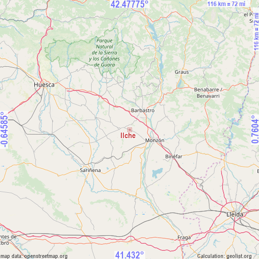
Ilche GPS coordinates[2]
41° 57' 25.272" North, 0° 3' 26.208" East
| Map corner | latitude | longitude |
|---|---|---|
| Upper-left | 42.47775°, | -0.64585° |
| Center: | 41.95702°, | 0.05728° |
| Lower-right: | 41.432°, | 0.7604° |
| Map W x H: | 116.3×116.3 km | = 72.3×72.3mi |
| max Lat: | 43.74134° ⇑27.5% North |
| Ilche: | 41.95702° |
| min Lat: | ⇓72.5% South 27.64134° |
| min Long | Ilche | max Long |
| -18.00367° | 0.05728° | 4.2899° |
| W 87.3%⇐ | ⇒12.7% E |
Elevation
Elevation of Ilche is 322 m = 1056 ft, and this is 276 m = 906 ft below average elevation for this country.
| Max E: |
1682 m = 5518 ft | 73.6% |
| Avg. | 598 m = 1962 ft | |
| Ilche | 322 m = 1056 ft | |
Min E: |
0 m = 0 ft | 26.4% |
See also: Spain elevation on elevation.city.
Geographical zone
Ilche is located in North temperate zone (between Tropic of Cancer and the Arctic Circle). Distance of this Northern Tropic circle is 2059.3 km =1279.6 mi to South.| Distance of | km | miles | from Ilche |
|---|---|---|---|
| North Pole | 5341.9 | 3319.3 | to North |
| Arctic Circle | 2736 | 1700.1 | to North |
| Tropic Cancer | 2059.3 | 1279.6 | to South |
| Equator | 4665.2 | 2898.8 | to South |


Nearby cities:
15 places around Ilche: (largest is in red/bold)
• Azara
14.5 km =9 mi,  330°
330°
• Barbastro
10.5 km =6.5 mi,  33°
33°
• Barbuñales
14.1 km =8.8 mi,  302°
302°
• Berbegal
5 km =3.1 mi,  273°
273°
• Castejón del Puente
8.4 km =5.2 mi,  86°
86°
• Castillazuelo
12.3 km =7.6 mi,  2°
2°
• Laluenga
10.3 km =6.4 mi, 302°
• Laperdiguera
9.4 km =5.8 mi,  293°
293°
• Monzón
12.4 km =7.7 mi,  114°
114°
• Peralta de Alcofea
10.7 km =6.6 mi,  254°
254°
• Peraltilla
12.5 km =7.8 mi, 329°
• Pozán de Vero
14.1 km =8.8 mi,  351°
351°
• Pueyo de Santa Cruz
13.7 km =8.5 mi,  143°
143°
• Salas Bajas
16.1 km =10 mi,  7°
7°
• Torres de Alcanadre
14 km =8.7 mi, 274°
Sources, notices
• [Note1] Compared only with cities in Spain existing in our database
• [Src1] Map data: © OpenStreetMap contributors (CC-BY-SA)
• [Src2] Other city data from geonames.org with taken over terms of usage.
• [Src3] Geographical zone / Annual Mean Temperature by Robert A. Rohde @ Wikipedia
