Monzón geodata
Monzón (Aragon) is a seat of a third-order administrative division; located in Spain in Europe/Madrid (GMT+2) time zone. With population of 17,042 people, there are 555 cities with bigger population in this country. Compared to other cities in Spain, 71.2% of cities are located further ↓South; 87.9% of cities are located further ←West and 76.4% of cities have higher elevation than Monzón. Note1


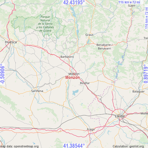
Monzón GPS coordinates[2]
41° 54' 39.024" North, 0° 11' 38.616" East
| Map corner | latitude | longitude |
|---|---|---|
| Upper-left | 42.43195°, | -0.50906° |
| Center: | 41.91084°, | 0.19406° |
| Lower-right: | 41.38544°, | 0.89719° |
| Map W x H: | 116.4×116.4 km | = 72.3×72.3mi |
| max Lat: | 43.74134° ⇑28.8% North |
| Monzón: | 41.91084° |
| min Lat: | ⇓71.2% South 27.64134° |
| min Long | Monzón | max Long |
| -18.00367° | 0.19406° | 4.2899° |
| W 87.9%⇐ | ⇒12.1% E |
Elevation
Elevation of Monzón is 280 m = 919 ft, and this is 318 m = 1043 ft below average elevation for this country.
| Max E: |
1682 m = 5518 ft | 76.4% |
| Avg. | 598 m = 1962 ft | |
| Monzón | 280 m = 919 ft | |
Min E: |
0 m = 0 ft | 23.6% |
See also: Spain elevation on elevation.city.
Geographical zone
Monzón is located in North temperate zone (between Tropic of Cancer and the Arctic Circle). Distance of this Northern Tropic circle is 2054.1 km =1276.4 mi to South.| Distance of | km | miles | from Monzón |
|---|---|---|---|
| North Pole | 5347 | 3322.5 | to North |
| Arctic Circle | 2741.1 | 1703.2 | to North |
| Tropic Cancer | 2054.1 | 1276.4 | to South |
| Equator | 4660 | 2895.6 | to South |


Nearby cities:
15 places around Monzón: (largest is in red/bold)
• Alfántega
9.9 km =6.2 mi,  202°
202°
• Barbastro
14.9 km =9.3 mi,  338°
338°
• Berbegal
17.2 km =10.7 mi,  288°
288°
• Binaced
9.5 km =5.9 mi,  176°
176°
• Binéfar
10.6 km =6.6 mi,  128°
128°
• Castejón del Puente
6.4 km =4 mi,  332°
332°
• Esplús
14.2 km =8.8 mi,  151°
151°
• Estada
18.2 km =11.3 mi,  9°
9°
• Estadilla
16.7 km =10.4 mi, 14°
• Fonz
12.3 km =7.6 mi,  25°
25°
• Ilche
12.4 km =7.7 mi, 294°
• Pueyo de Santa Cruz
6.6 km =4.1 mi,  207°
207°
• San Esteban de Litera (Sant Esteve de Llitera)
11 km =6.8 mi,  93°
93°
• Tamarit de Llitera / Tamarite de Litera
19.4 km =12.1 mi,  103°
103°
• el Campell / Alcampell
19.7 km =12.2 mi, 91°
Sources, notices
• [Note1] Compared only with cities in Spain existing in our database
• [Src1] Map data: © OpenStreetMap contributors (CC-BY-SA)
• [Src2] Other city data from geonames.org with taken over terms of usage.
• [Src3] Geographical zone / Annual Mean Temperature by Robert A. Rohde @ Wikipedia
