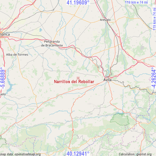
Narrillos del Rebollar geodata
Narrillos del Rebollar (Castille and León) is a seat of a third-order administrative division; located in Spain in Europe/Madrid (GMT+2) time zone. With population of 65 people, there are 6290 cities with bigger population in this country. Compared to other cities in Spain, 58.6% of cities are located further ↑North; 72% of cities are located further →East and 99.3% of cities have lower elevation than Narrillos del Rebollar. Note1
Administrative division(s):
- Level 1: Castille and León
- Level 2: Provincia de Ávila
- Level 3: Narrillos del Rebollar
Current local time in Narrillos del Rebollar:
11:57 PM, ThursdayDifference from your time zone: hours


Narrillos del Rebollar GPS coordinates[2]
40° 39' 53.568" North, 4° 57' 56.772" West
| Map corner | latitude | longitude |
|---|---|---|
| Upper-left | 41.19609°, | -5.66889° |
| Center: | 40.66488°, | -4.96577° |
| Lower-right: | 40.12941°, | -4.26264° |
| Map W x H: | 118.6×118.6 km | = 73.7×73.7mi |
| max Lat: | 43.74134° ⇑58.6% North |
| Narrillos del Rebollar: | 40.66488° |
| min Lat: | ⇓41.4% South 27.64134° |
| min Long | Narrillos del R | max Long |
| -18.00367° | -4.96577° | 4.2899° |
| W 28%⇐ | ⇒72% E |
Elevation
Elevation of Narrillos del Rebollar is 1380 m = 4528 ft, and this is 782 m = 2566 ft above average elevation for this country.
| Max E: |
1682 m = 5518 ft | 0.7% |
| Narrillos del Rebollar | 1380 m 4528 ft | |
| Avg. | 598 m = 1962 ft | |
Min E: |
0 m = 0 ft | 99.3% |
See also: Spain elevation on elevation.city.
Geographical zone
Narrillos del Rebollar is located in North temperate zone (between Tropic of Cancer and the Arctic Circle). Distance of this Northern Tropic circle is 1915.6 km =1190.3 mi to South.| Distance of | km | miles | from Narrillos del Rebollar |
|---|---|---|---|
| North Pole | 5485.6 | 3408.6 | to North |
| Arctic Circle | 2879.7 | 1789.4 | to North |
| Tropic Cancer | 1915.6 | 1190.3 | to South |
| Equator | 4521.5 | 2809.5 | to South |


Nearby cities:
15 places around Narrillos del Rebollar: (largest is in red/bold)
• Amavida
13.2 km =8.2 mi,  219°
219°
• Brabos
12.8 km =8 mi,  10°
10°
• Chamartín
4.3 km =2.7 mi, 9°
• Cillán
4.8 km =3 mi,  344°
344°
• Hurtumpascual
12.8 km =8 mi,  283°
283°
• Manjabálago
9.4 km =5.8 mi,  269°
269°
• Muñana
9.2 km =5.7 mi,  206°
206°
• Muñico
7 km =4.3 mi,  311°
311°
• Muñogalindo
8.9 km =5.5 mi,  140°
140°
• Muñopepe
12.9 km =8 mi,  105°
105°
• Padiernos
11.2 km =7 mi,  115°
115°
• Sanchorreja
4.3 km =2.7 mi,  90°
90°
• Solosancho
13.5 km =8.4 mi,  157°
157°
• Valdecasa
3.9 km =2.4 mi,  260°
260°
• Villaflor
13 km =8.1 mi,  36°
36°
Sources, notices
• [Note1] Compared only with cities in Spain existing in our database
• [Src1] Map data: © OpenStreetMap contributors (CC-BY-SA)
• [Src2] Other city data from geonames.org with taken over terms of usage.
• [Src3] Geographical zone / Annual Mean Temperature by Robert A. Rohde @ Wikipedia
