Muñico geodata
Muñico (Castille and León) is a seat of a third-order administrative division; located in Spain in Europe/Madrid (GMT+2) time zone. With population of 126 people, there are 5628 cities with bigger population in this country. Compared to other cities in Spain, 57.9% of cities are located further ↑North; 72.9% of cities are located further →East and 92.9% of cities have lower elevation than Muñico. Note1


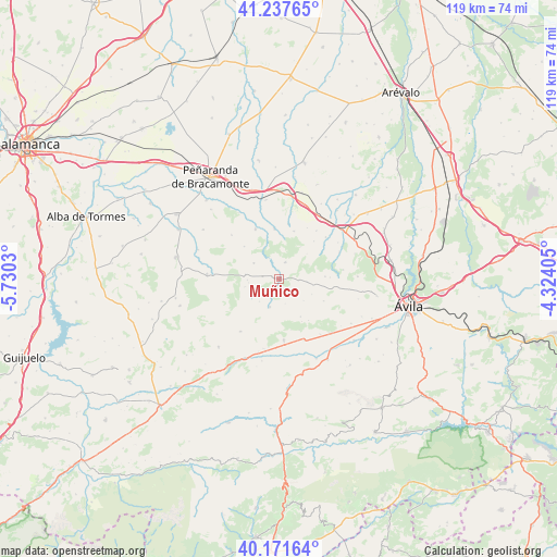
Muñico GPS coordinates[2]
40° 42' 24.408" North, 5° 1' 37.812" West
| Map corner | latitude | longitude |
|---|---|---|
| Upper-left | 41.23765°, | -5.7303° |
| Center: | 40.70678°, | -5.02717° |
| Lower-right: | 40.17164°, | -4.32405° |
| Map W x H: | 118.5×118.5 km | = 73.6×73.6mi |
| max Lat: | 43.74134° ⇑57.9% North |
| Muñico: | 40.70678° |
| min Lat: | ⇓42.1% South 27.64134° |
| min Long | Muñico | max Long |
| -18.00367° | -5.02717° | 4.2899° |
| W 27.1%⇐ | ⇒72.9% E |
Elevation
Elevation of Muñico is 1090 m = 3576 ft, and this is 492 m = 1614 ft above average elevation for this country.
| Max E: |
1682 m = 5518 ft | 7.1% |
| Muñico | 1090 m 3576 ft | |
| Avg. | 598 m = 1962 ft | |
Min E: |
0 m = 0 ft | 92.9% |
See also: Spain elevation on elevation.city.
Geographical zone
Muñico is located in North temperate zone (between Tropic of Cancer and the Arctic Circle). Distance of this Northern Tropic circle is 1920.3 km =1193.2 mi to South.| Distance of | km | miles | from Muñico |
|---|---|---|---|
| North Pole | 5480.9 | 3405.7 | to North |
| Arctic Circle | 2875 | 1786.4 | to North |
| Tropic Cancer | 1920.3 | 1193.2 | to South |
| Equator | 4526.2 | 2812.4 | to South |


Nearby cities:
15 places around Muñico: (largest is in red/bold)
• Blascomillán
11.7 km =7.3 mi,  334°
334°
• Brabos
10.9 km =6.8 mi,  42°
42°
• Chamartín
5.9 km =3.7 mi,  94°
94°
• Cillán
3.9 km =2.4 mi, 90°
• Gallegos de Sobrinos
7.3 km =4.5 mi,  278°
278°
• Herreros de Suso
10.8 km =6.7 mi,  354°
354°
• Hurtumpascual
7.5 km =4.7 mi,  257°
257°
• Manjabálago
6.3 km =3.9 mi,  221°
221°
• Muñana
13 km =8.1 mi,  175°
175°
• Narrillos del Rebollar
7 km =4.3 mi,  131°
131°
• San García de Ingelmos
10.2 km =6.3 mi,  313°
313°
• Sanchorreja
10.6 km =6.6 mi,  116°
116°
• Sigeres
13 km =8.1 mi, 37°
• Valdecasa
5.4 km =3.4 mi,  166°
166°
• Vita
11.8 km =7.3 mi,  8°
8°
Sources, notices
• [Note1] Compared only with cities in Spain existing in our database
• [Src1] Map data: © OpenStreetMap contributors (CC-BY-SA)
• [Src2] Other city data from geonames.org with taken over terms of usage.
• [Src3] Geographical zone / Annual Mean Temperature by Robert A. Rohde @ Wikipedia
