Huerto geodata
Huerto (Aragon) is a seat of a third-order administrative division; located in Spain in Europe/Madrid (GMT+2) time zone. With population of 257 people, there are 4702 cities with bigger population in this country. Compared to other cities in Spain, 71.6% of cities are located further ↓South; 85.8% of cities are located further ←West and 70.4% of cities have higher elevation than Huerto. Note1


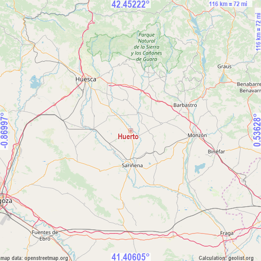
Huerto GPS coordinates[2]
41° 55' 52.608" North, 0° 10' 0.624" West
| Map corner | latitude | longitude |
|---|---|---|
| Upper-left | 42.45222°, | -0.86997° |
| Center: | 41.93128°, | -0.16684° |
| Lower-right: | 41.40605°, | 0.53628° |
| Map W x H: | 116.3×116.3 km | = 72.3×72.3mi |
| max Lat: | 43.74134° ⇑28.4% North |
| Huerto: | 41.93128° |
| min Lat: | ⇓71.6% South 27.64134° |
| min Long | Huerto | max Long |
| -18.00367° | -0.16684° | 4.2899° |
| W 85.8%⇐ | ⇒14.2% E |
Elevation
Elevation of Huerto is 374 m = 1227 ft, and this is 224 m = 735 ft below average elevation for this country.
| Max E: |
1682 m = 5518 ft | 70.4% |
| Avg. | 598 m = 1962 ft | |
| Huerto | 374 m = 1227 ft | |
Min E: |
0 m = 0 ft | 29.6% |
See also: Spain elevation on elevation.city.
Geographical zone
Huerto is located in North temperate zone (between Tropic of Cancer and the Arctic Circle). Distance of this Northern Tropic circle is 2056.4 km =1277.8 mi to South.| Distance of | km | miles | from Huerto |
|---|---|---|---|
| North Pole | 5344.7 | 3321 | to North |
| Arctic Circle | 2738.9 | 1701.9 | to North |
| Tropic Cancer | 2056.4 | 1277.8 | to South |
| Equator | 4662.3 | 2897 | to South |


Nearby cities:
15 places around Huerto: (largest is in red/bold)
• Alberuela de Tubo
4.7 km =2.9 mi,  237°
237°
• Antillón
11.7 km =7.3 mi,  1°
1°
• Barbuñales
12.4 km =7.7 mi,  32°
32°
• Berbegal
13.9 km =8.6 mi,  76°
76°
• Capdesaso
9.9 km =6.2 mi,  187°
187°
• Laluenga
13 km =8.1 mi,  49°
49°
• Lalueza
12.5 km =7.8 mi,  215°
215°
• Laperdiguera
11.9 km =7.4 mi,  56°
56°
• Peralta de Alcofea
8.2 km =5.1 mi,  89°
89°
• Pertusa
8.5 km =5.3 mi,  22°
22°
• Poleñino
13.7 km =8.5 mi, 239°
• Salillas
8.5 km =5.3 mi,  326°
326°
• Sesa
9.6 km =6 mi,  317°
317°
• Torres de Alcanadre
6.1 km =3.8 mi, 49°
• Tramaced
11.8 km =7.3 mi,  293°
293°
Sources, notices
• [Note1] Compared only with cities in Spain existing in our database
• [Src1] Map data: © OpenStreetMap contributors (CC-BY-SA)
• [Src2] Other city data from geonames.org with taken over terms of usage.
• [Src3] Geographical zone / Annual Mean Temperature by Robert A. Rohde @ Wikipedia
