Lalueza geodata
Lalueza (Aragon) is a seat of a third-order administrative division; located in Spain in Europe/Madrid (GMT+2) time zone. In our database, there are 6762 cities with bigger population. Compared to other cities in Spain, 69.6% of cities are located further ↓South; 85.1% of cities are located further ←West and 75.9% of cities have higher elevation than Lalueza. Note1


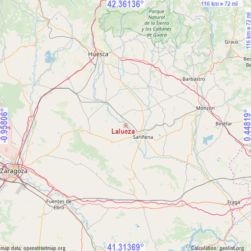
Lalueza GPS coordinates[2]
41° 50' 22.812" North, 0° 15' 17.748" West
| Map corner | latitude | longitude |
|---|---|---|
| Upper-left | 42.36136°, | -0.95806° |
| Center: | 41.83967°, | -0.25493° |
| Lower-right: | 41.31369°, | 0.44819° |
| Map W x H: | 116.5×116.5 km | = 72.4×72.4mi |
| max Lat: | 43.74134° ⇑30.4% North |
| Lalueza: | 41.83967° |
| min Lat: | ⇓69.6% South 27.64134° |
| min Long | Lalueza | max Long |
| -18.00367° | -0.25493° | 4.2899° |
| W 85.1%⇐ | ⇒14.9% E |
Elevation
Elevation of Lalueza is 286 m = 938 ft, and this is 312 m = 1024 ft below average elevation for this country.
| Max E: |
1682 m = 5518 ft | 75.9% |
| Avg. | 598 m = 1962 ft | |
| Lalueza | 286 m = 938 ft | |
Min E: |
0 m = 0 ft | 24.1% |
See also: Spain elevation on elevation.city.
Geographical zone
Lalueza is located in North temperate zone (between Tropic of Cancer and the Arctic Circle). Distance of this Northern Tropic circle is 2046.2 km =1271.4 mi to South.| Distance of | km | miles | from Lalueza |
|---|---|---|---|
| North Pole | 5354.9 | 3327.4 | to North |
| Arctic Circle | 2749 | 1708.1 | to North |
| Tropic Cancer | 2046.2 | 1271.4 | to South |
| Equator | 4652.1 | 2890.7 | to South |


Nearby cities:
15 places around Lalueza: (largest is in red/bold)
• Albalatillo
14.4 km =8.9 mi,  143°
143°
• Alberuela de Tubo
8.4 km =5.2 mi,  23°
23°
• Alcubierre
16.8 km =10.4 mi,  257°
257°
• Almuniente
17.8 km =11.1 mi,  313°
313°
• Capdesaso
6 km =3.7 mi,  86°
86°
• Grañén
14.7 km =9.1 mi,  319°
319°
• Huerto
12.5 km =7.8 mi,  35°
35°
• Lanaja
9.9 km =6.2 mi,  219°
219°
• Poleñino
5.7 km =3.5 mi, 306°
• Robres
17.3 km =10.7 mi,  280°
280°
• Salillas
17.5 km =10.9 mi,  8°
8°
• Sariñena
9.7 km =6 mi,  123°
123°
• Sesa
17.3 km =10.7 mi,  2°
2°
• Torres de Alcanadre
18.5 km =11.5 mi, 40°
• Tramaced
15.3 km =9.5 mi,  346°
346°
Sources, notices
• [Note1] Compared only with cities in Spain existing in our database
• [Src1] Map data: © OpenStreetMap contributors (CC-BY-SA)
• [Src2] Other city data from geonames.org with taken over terms of usage.
• [Src3] Geographical zone / Annual Mean Temperature by Robert A. Rohde @ Wikipedia
