Poleñino geodata
Poleñino (Aragon) is a seat of a third-order administrative division; located in Spain in Europe/Madrid (GMT+2) time zone. With population of 250 people, there are 4740 cities with bigger population in this country. Compared to other cities in Spain, 70.3% of cities are located further ↓South; 84.5% of cities are located further ←West and 74.7% of cities have higher elevation than Poleñino. Note1


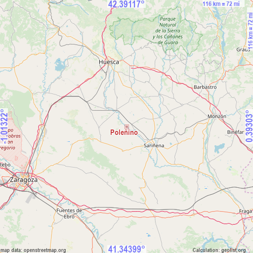
Poleñino GPS coordinates[2]
41° 52' 10.992" North, 0° 18' 36.324" West
| Map corner | latitude | longitude |
|---|---|---|
| Upper-left | 42.39117°, | -1.01322° |
| Center: | 41.86972°, | -0.31009° |
| Lower-right: | 41.34399°, | 0.39303° |
| Map W x H: | 116.4×116.4 km | = 72.3×72.3mi |
| max Lat: | 43.74134° ⇑29.7% North |
| Poleñino: | 41.86972° |
| min Lat: | ⇓70.3% South 27.64134° |
| min Long | Poleñino | max Long |
| -18.00367° | -0.31009° | 4.2899° |
| W 84.5%⇐ | ⇒15.5% E |
Elevation
Elevation of Poleñino is 300 m = 984 ft, and this is 298 m = 978 ft below average elevation for this country.
| Max E: |
1682 m = 5518 ft | 74.7% |
| Avg. | 598 m = 1962 ft | |
| Poleñino | 300 m = 984 ft | |
Min E: |
0 m = 0 ft | 25.3% |
See also: Spain elevation on elevation.city.
Geographical zone
Poleñino is located in North temperate zone (between Tropic of Cancer and the Arctic Circle). Distance of this Northern Tropic circle is 2049.6 km =1273.6 mi to South.| Distance of | km | miles | from Poleñino |
|---|---|---|---|
| North Pole | 5351.6 | 3325.3 | to North |
| Arctic Circle | 2745.7 | 1706.1 | to North |
| Tropic Cancer | 2049.6 | 1273.6 | to South |
| Equator | 4655.5 | 2892.8 | to South |


Nearby cities:
15 places around Poleñino: (largest is in red/bold)
• Alberuela de Tubo
9 km =5.6 mi,  61°
61°
• Alcubierre
13.7 km =8.5 mi,  239°
239°
• Almuniente
12.2 km =7.6 mi,  316°
316°
• Barbués
15.3 km =9.5 mi, 323°
• Capdesaso
10.9 km =6.8 mi,  105°
105°
• Grañén
9.3 km =5.8 mi,  328°
328°
• Huerto
13.7 km =8.5 mi, 59°
• Lalueza
5.7 km =3.5 mi,  126°
126°
• Lanaja
11.2 km =7 mi,  188°
188°
• Piracés
15 km =9.3 mi,  357°
357°
• Robres
12.5 km =7.8 mi,  268°
268°
• Sariñena
15.3 km =9.5 mi,  124°
124°
• Sesa
14.9 km =9.3 mi,  21°
21°
• Torres de Barbués
14.4 km =8.9 mi,  314°
314°
• Tramaced
11.6 km =7.2 mi,  5°
5°
Sources, notices
• [Note1] Compared only with cities in Spain existing in our database
• [Src1] Map data: © OpenStreetMap contributors (CC-BY-SA)
• [Src2] Other city data from geonames.org with taken over terms of usage.
• [Src3] Geographical zone / Annual Mean Temperature by Robert A. Rohde @ Wikipedia
