Sesa geodata
Sesa (Aragon) is a seat of a third-order administrative division; located in Spain in Europe/Madrid (GMT+2) time zone. With population of 238 people, there are 4817 cities with bigger population in this country. Compared to other cities in Spain, 73.7% of cities are located further ↓South; 85.2% of cities are located further ←West and 67.1% of cities have higher elevation than Sesa. Note1


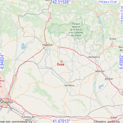
Sesa GPS coordinates[2]
41° 59' 41.424" North, 0° 14' 42.396" West
| Map corner | latitude | longitude |
|---|---|---|
| Upper-left | 42.51526°, | -0.94824° |
| Center: | 41.99484°, | -0.24511° |
| Lower-right: | 41.47013°, | 0.45802° |
| Map W x H: | 116.2×116.2 km | = 72.2×72.2mi |
| max Lat: | 43.74134° ⇑26.3% North |
| Sesa: | 41.99484° |
| min Lat: | ⇓73.7% South 27.64134° |
| min Long | Sesa | max Long |
| -18.00367° | -0.24511° | 4.2899° |
| W 85.2%⇐ | ⇒14.8% E |
Elevation
Elevation of Sesa is 430 m = 1411 ft, and this is 168 m = 551 ft below average elevation for this country.
| Max E: |
1682 m = 5518 ft | 67.1% |
| Avg. | 598 m = 1962 ft | |
| Sesa | 430 m = 1411 ft | |
Min E: |
0 m = 0 ft | 32.9% |
See also: Spain elevation on elevation.city.
Geographical zone
Sesa is located in North temperate zone (between Tropic of Cancer and the Arctic Circle). Distance of this Northern Tropic circle is 2063.5 km =1282.2 mi to South.| Distance of | km | miles | from Sesa |
|---|---|---|---|
| North Pole | 5337.7 | 3316.7 | to North |
| Arctic Circle | 2731.8 | 1697.5 | to North |
| Tropic Cancer | 2063.5 | 1282.2 | to South |
| Equator | 4669.4 | 2901.4 | to South |


Nearby cities:
15 places around Sesa: (largest is in red/bold)
• Albero Alto
9.8 km =6.1 mi,  309°
309°
• Albero Bajo
11.6 km =7.2 mi,  286°
286°
• Alberuela de Tubo
9.9 km =6.2 mi,  165°
165°
• Alcalá del Obispo
9.9 km =6.2 mi,  337°
337°
• Antillón
8.2 km =5.1 mi,  55°
55°
• Argavieso
7 km =4.3 mi, 336°
• Barbuñales
13.5 km =8.4 mi,  75°
75°
• Grañén
11.9 km =7.4 mi,  239°
239°
• Huerto
9.6 km =6 mi,  137°
137°
• Novales
5.4 km =3.4 mi,  320°
320°
• Pertusa
9.8 km =6.1 mi,  85°
85°
• Piracés
6.1 km =3.8 mi,  280°
280°
• Salillas
1.8 km =1.1 mi, 89°
• Torres de Alcanadre
11.5 km =7.1 mi,  105°
105°
• Tramaced
5 km =3.1 mi, 240°
Sources, notices
• [Note1] Compared only with cities in Spain existing in our database
• [Src1] Map data: © OpenStreetMap contributors (CC-BY-SA)
• [Src2] Other city data from geonames.org with taken over terms of usage.
• [Src3] Geographical zone / Annual Mean Temperature by Robert A. Rohde @ Wikipedia
