Alberuela de Tubo geodata
Alberuela de Tubo (Aragon) is a seat of a third-order administrative division; located in Spain in Europe/Madrid (GMT+2) time zone. With population of 376 people, there are 4224 cities with bigger population in this country. Compared to other cities in Spain, 71.1% of cities are located further ↓South; 85.4% of cities are located further ←West and 71.8% of cities have higher elevation than Alberuela de Tubo. Note1


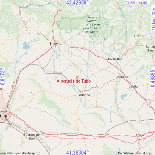
Alberuela de Tubo GPS coordinates[2]
41° 54' 30.456" North, 0° 12' 51.048" West
| Map corner | latitude | longitude |
|---|---|---|
| Upper-left | 42.42959°, | -0.9173° |
| Center: | 41.90846°, | -0.21418° |
| Lower-right: | 41.38304°, | 0.48895° |
| Map W x H: | 116.4×116.4 km | = 72.3×72.3mi |
| max Lat: | 43.74134° ⇑28.9% North |
| Alberuela de Tubo: | 41.90846° |
| min Lat: | ⇓71.1% South 27.64134° |
| min Long | Alberuela de Tu | max Long |
| -18.00367° | -0.21418° | 4.2899° |
| W 85.4%⇐ | ⇒14.6% E |
Elevation
Elevation of Alberuela de Tubo is 352 m = 1155 ft, and this is 246 m = 807 ft below average elevation for this country.
| Max E: |
1682 m = 5518 ft | 71.8% |
| Avg. | 598 m = 1962 ft | |
| Alberuela de Tubo | 352 m = 1155 ft | |
Min E: |
0 m = 0 ft | 28.2% |
See also: Spain elevation on elevation.city.
Geographical zone
Alberuela de Tubo is located in North temperate zone (between Tropic of Cancer and the Arctic Circle). Distance of this Northern Tropic circle is 2053.9 km =1276.2 mi to South.| Distance of | km | miles | from Alberuela de Tubo |
|---|---|---|---|
| North Pole | 5347.3 | 3322.7 | to North |
| Arctic Circle | 2741.4 | 1703.4 | to North |
| Tropic Cancer | 2053.9 | 1276.2 | to South |
| Equator | 4659.8 | 2895.5 | to South |


Nearby cities:
15 places around Alberuela de Tubo: (largest is in red/bold)
• Antillón
14.9 km =9.3 mi,  16°
16°
• Capdesaso
7.7 km =4.8 mi,  160°
160°
• Grañén
13.3 km =8.3 mi,  285°
285°
• Huerto
4.7 km =2.9 mi,  57°
57°
• Lalueza
8.4 km =5.2 mi,  203°
203°
• Novales
15 km =9.3 mi,  336°
336°
• Peralta de Alcofea
12.4 km =7.7 mi,  78°
78°
• Pertusa
12.7 km =7.9 mi,  34°
34°
• Piracés
13.7 km =8.5 mi,  321°
321°
• Poleñino
9 km =5.6 mi,  241°
241°
• Salillas
9.6 km =6 mi,  355°
355°
• Sariñena
13.8 km =8.6 mi, 160°
• Sesa
9.9 km =6.2 mi,  345°
345°
• Torres de Alcanadre
10.8 km =6.7 mi,  52°
52°
• Tramaced
10 km =6.2 mi, 316°
Sources, notices
• [Note1] Compared only with cities in Spain existing in our database
• [Src1] Map data: © OpenStreetMap contributors (CC-BY-SA)
• [Src2] Other city data from geonames.org with taken over terms of usage.
• [Src3] Geographical zone / Annual Mean Temperature by Robert A. Rohde @ Wikipedia
