Hoyocasero geodata
Hoyocasero (Castille and León) is a seat of a third-order administrative division; located in Spain in Europe/Madrid (GMT+2) time zone. With population of 365 people, there are 4259 cities with bigger population in this country. Compared to other cities in Spain, 64.1% of cities are located further ↑North; 72.2% of cities are located further →East and 99.1% of cities have lower elevation than Hoyocasero. Note1
Administrative division(s):
- Level 1: Castille and León
- Level 2: Provincia de Ávila
- Level 3: Hoyocasero


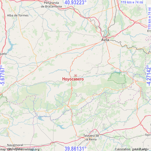
Hoyocasero GPS coordinates[2]
40° 23' 56.04" North, 4° 58' 28.38" West
| Map corner | latitude | longitude |
|---|---|---|
| Upper-left | 40.93223°, | -5.67767° |
| Center: | 40.3989°, | -4.97455° |
| Lower-right: | 39.86131°, | -4.27142° |
| Map W x H: | 119.1×119.1 km | = 74×74mi |
| max Lat: | 43.74134° ⇑64.1% North |
| Hoyocasero: | 40.3989° |
| min Lat: | ⇓35.9% South 27.64134° |
| min Long | Hoyocasero | max Long |
| -18.00367° | -4.97455° | 4.2899° |
| W 27.8%⇐ | ⇒72.2% E |
Elevation
Elevation of Hoyocasero is 1358 m = 4455 ft, and this is 760 m = 2493 ft above average elevation for this country.
| Max E: |
1682 m = 5518 ft | 0.90000000000001% |
| Hoyocasero | 1358 m 4455 ft | |
| Avg. | 598 m = 1962 ft | |
Min E: |
0 m = 0 ft | 99.1% |
See also: Spain elevation on elevation.city.
Geographical zone
Hoyocasero is located in North temperate zone (between Tropic of Cancer and the Arctic Circle). Distance of this Northern Tropic circle is 1886 km =1171.9 mi to South.| Distance of | km | miles | from Hoyocasero |
|---|---|---|---|
| North Pole | 5515.1 | 3426.9 | to North |
| Arctic Circle | 2909.2 | 1807.7 | to North |
| Tropic Cancer | 1886 | 1171.9 | to South |
| Equator | 4491.9 | 2791.1 | to South |


Nearby cities:
15 places around Hoyocasero: (largest is in red/bold)
• Cepeda la Mora
9 km =5.6 mi,  316°
316°
• Cuevas del Valle
12 km =7.5 mi,  194°
194°
• Garganta del Villar
12.3 km =7.6 mi,  297°
297°
• Hoyos de Miguel Muñoz
7.9 km =4.9 mi,  264°
264°
• Mengamuñoz
11.4 km =7.1 mi,  349°
349°
• Navadijos
9.6 km =6 mi,  287°
287°
• Navalacruz
5.9 km =3.7 mi,  38°
38°
• Navalosa
3.8 km =2.4 mi,  84°
84°
• Navaquesera
6.1 km =3.8 mi,  61°
61°
• Navarrevisca
7.9 km =4.9 mi,  119°
119°
• Navatalgordo
8.9 km =5.5 mi, 78°
• San Esteban del Valle
13.8 km =8.6 mi,  182°
182°
• San Martín del Pimpollar
7.6 km =4.7 mi,  243°
243°
• Serranillos
8.8 km =5.5 mi,  142°
142°
• Villarejo del Valle
12.7 km =7.9 mi, 188°
Sources, notices
• [Note1] Compared only with cities in Spain existing in our database
• [Src1] Map data: © OpenStreetMap contributors (CC-BY-SA)
• [Src2] Other city data from geonames.org with taken over terms of usage.
• [Src3] Geographical zone / Annual Mean Temperature by Robert A. Rohde @ Wikipedia
