Serranillos geodata
Serranillos (Castille and León) is a seat of a third-order administrative division; located in Spain in Europe/Madrid (GMT+2) time zone. With population of 359 people, there are 4279 cities with bigger population in this country. Compared to other cities in Spain, 65.1% of cities are located further ↑North; 71.3% of cities are located further →East and 97.4% of cities have lower elevation than Serranillos. Note1
Administrative division(s):
- Level 1: Castille and León
- Level 2: Provincia de Ávila
- Level 3: Serranillos


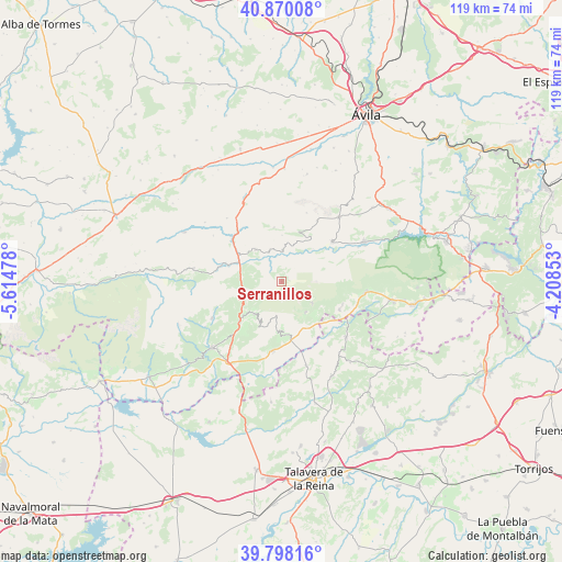
Serranillos GPS coordinates[2]
40° 20' 10.5" North, 4° 54' 41.94" West
| Map corner | latitude | longitude |
|---|---|---|
| Upper-left | 40.87008°, | -5.61478° |
| Center: | 40.33625°, | -4.91165° |
| Lower-right: | 39.79816°, | -4.20853° |
| Map W x H: | 119.2×119.2 km | = 74.1×74.1mi |
| max Lat: | 43.74134° ⇑65.1% North |
| Serranillos: | 40.33625° |
| min Lat: | ⇓34.9% South 27.64134° |
| min Long | Serranillos | max Long |
| -18.00367° | -4.91165° | 4.2899° |
| W 28.7%⇐ | ⇒71.3% E |
Elevation
Elevation of Serranillos is 1224 m = 4016 ft, and this is 626 m = 2054 ft above average elevation for this country.
| Max E: |
1682 m = 5518 ft | 2.6% |
| Serranillos | 1224 m 4016 ft | |
| Avg. | 598 m = 1962 ft | |
Min E: |
0 m = 0 ft | 97.4% |
See also: Spain elevation on elevation.city.
Geographical zone
Serranillos is located in North temperate zone (between Tropic of Cancer and the Arctic Circle). Distance of this Northern Tropic circle is 1879.1 km =1167.6 mi to South.| Distance of | km | miles | from Serranillos |
|---|---|---|---|
| North Pole | 5522.1 | 3431.3 | to North |
| Arctic Circle | 2916.2 | 1812 | to North |
| Tropic Cancer | 1879.1 | 1167.6 | to South |
| Equator | 4485 | 2786.8 | to South |


Nearby cities:
15 places around Serranillos: (largest is in red/bold)
• Cuevas del Valle
9.5 km =5.9 mi,  240°
240°
• Gavilanes
8.2 km =5.1 mi,  142°
142°
• Hoyocasero
8.8 km =5.5 mi,  322°
322°
• Mijares
7.8 km =4.8 mi,  124°
124°
• Mombeltrán
12.4 km =7.7 mi,  226°
226°
• Navalacruz
11.6 km =7.2 mi,  351°
351°
• Navalosa
7.5 km =4.7 mi, 348°
• Navaquesera
9.9 km =6.2 mi,  0°
0°
• Navarrevisca
3.5 km =2.2 mi,  26°
26°
• Navatalgordo
9.4 km =5.8 mi,  21°
21°
• Pedro Bernardo
10.5 km =6.5 mi,  179°
179°
• San Esteban del Valle
9.1 km =5.7 mi,  221°
221°
• San Martín del Pimpollar
12.6 km =7.8 mi,  286°
286°
• Santa Cruz del Valle
12.1 km =7.5 mi, 218°
• Villarejo del Valle
9.1 km =5.7 mi, 232°
Sources, notices
• [Note1] Compared only with cities in Spain existing in our database
• [Src1] Map data: © OpenStreetMap contributors (CC-BY-SA)
• [Src2] Other city data from geonames.org with taken over terms of usage.
• [Src3] Geographical zone / Annual Mean Temperature by Robert A. Rohde @ Wikipedia
