Navatalgordo geodata
Navatalgordo (Castille and León) is a seat of a third-order administrative division; located in Spain in Europe/Madrid (GMT+2) time zone. With population of 302 people, there are 4495 cities with bigger population in this country. Compared to other cities in Spain, 63.7% of cities are located further ↑North; 70.8% of cities are located further →East and 98.2% of cities have lower elevation than Navatalgordo. Note1
Administrative division(s):
- Level 1: Castille and León
- Level 2: Provincia de Ávila
- Level 3: Navatalgordo


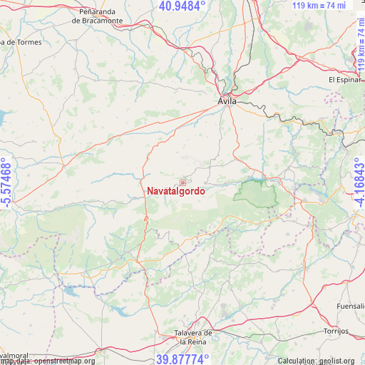
Navatalgordo GPS coordinates[2]
40° 24' 54.72" North, 4° 52' 17.58" West
| Map corner | latitude | longitude |
|---|---|---|
| Upper-left | 40.9484°, | -5.57468° |
| Center: | 40.4152°, | -4.87155° |
| Lower-right: | 39.87774°, | -4.16843° |
| Map W x H: | 119×119 km | = 73.9×73.9mi |
| max Lat: | 43.74134° ⇑63.7% North |
| Navatalgordo: | 40.4152° |
| min Lat: | ⇓36.3% South 27.64134° |
| min Long | Navatalgordo | max Long |
| -18.00367° | -4.87155° | 4.2899° |
| W 29.2%⇐ | ⇒70.8% E |
Elevation
Elevation of Navatalgordo is 1268 m = 4160 ft, and this is 670 m = 2198 ft above average elevation for this country.
| Max E: |
1682 m = 5518 ft | 1.8% |
| Navatalgordo | 1268 m 4160 ft | |
| Avg. | 598 m = 1962 ft | |
Min E: |
0 m = 0 ft | 98.2% |
See also: Spain elevation on elevation.city.
Geographical zone
Navatalgordo is located in North temperate zone (between Tropic of Cancer and the Arctic Circle). Distance of this Northern Tropic circle is 1887.8 km =1173 mi to South.| Distance of | km | miles | from Navatalgordo |
|---|---|---|---|
| North Pole | 5513.3 | 3425.8 | to North |
| Arctic Circle | 2907.4 | 1806.6 | to North |
| Tropic Cancer | 1887.8 | 1173 | to South |
| Equator | 4493.7 | 2792.3 | to South |


Nearby cities:
15 places around Navatalgordo: (largest is in red/bold)
• Burgohondo
7.3 km =4.5 mi,  90°
90°
• Gavilanes
15.3 km =9.5 mi,  174°
174°
• Hoyocasero
8.9 km =5.5 mi,  258°
258°
• Mengamuñoz
14.4 km =8.9 mi,  311°
311°
• Mijares
13.5 km =8.4 mi, 167°
• Navalacruz
5.8 km =3.6 mi,  298°
298°
• Navalmoral
10.1 km =6.3 mi,  60°
60°
• Navalosa
5.2 km =3.2 mi,  253°
253°
• Navaluenga
13.8 km =8.6 mi, 91°
• Navaquesera
3.5 km =2.2 mi,  289°
289°
• Navarredondilla
6 km =3.7 mi,  44°
44°
• Navarrevisca
6 km =3.7 mi,  198°
198°
• San Juan del Molinillo
6.7 km =4.2 mi, 43°
• Serranillos
9.4 km =5.8 mi, 201°
• Sotalbo
14.2 km =8.8 mi,  8°
8°
Sources, notices
• [Note1] Compared only with cities in Spain existing in our database
• [Src1] Map data: © OpenStreetMap contributors (CC-BY-SA)
• [Src2] Other city data from geonames.org with taken over terms of usage.
• [Src3] Geographical zone / Annual Mean Temperature by Robert A. Rohde @ Wikipedia
