Horche geodata
Horche (Castille-La Mancha) is a seat of a third-order administrative division; located in Spain in Europe/Madrid (GMT+2) time zone. With population of 1,853 people, there are 2257 cities with bigger population in this country. Compared to other cities in Spain, 60.6% of cities are located further ↑North; 53.4% of cities are located further ←West and 76.4% of cities have lower elevation than Horche. Note1
Administrative division(s):
- Level 1: Castille-La Mancha
- Level 2: Provincia de Guadalajara
- Level 3: Horche


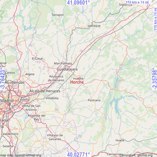
Horche GPS coordinates[2]
40° 33' 50.364" North, 3° 3' 39.96" West
| Map corner | latitude | longitude |
|---|---|---|
| Upper-left | 41.09601°, | -3.76423° |
| Center: | 40.56399°, | -3.0611° |
| Lower-right: | 40.02771°, | -2.35798° |
| Map W x H: | 118.8×118.8 km | = 73.8×73.8mi |
| max Lat: | 43.74134° ⇑60.6% North |
| Horche: | 40.56399° |
| min Lat: | ⇓39.4% South 27.64134° |
| min Long | Horche | max Long |
| -18.00367° | -3.0611° | 4.2899° |
| W 53.4%⇐ | ⇒46.6% E |
Elevation
Elevation of Horche is 864 m = 2835 ft, and this is 266 m = 873 ft above average elevation for this country.
| Max E: |
1682 m = 5518 ft | 23.6% |
| Horche | 864 m 2835 ft | |
| Avg. | 598 m = 1962 ft | |
Min E: |
0 m = 0 ft | 76.4% |
See also: Spain elevation on elevation.city.
Geographical zone
Horche is located in North temperate zone (between Tropic of Cancer and the Arctic Circle). Distance of this Northern Tropic circle is 1904.4 km =1183.3 mi to South.| Distance of | km | miles | from Horche |
|---|---|---|---|
| North Pole | 5496.8 | 3415.6 | to North |
| Arctic Circle | 2890.9 | 1796.3 | to North |
| Tropic Cancer | 1904.4 | 1183.3 | to South |
| Equator | 4510.3 | 2802.6 | to South |


Nearby cities:
15 places around Horche: (largest is in red/bold)
• Aranzueque
8.2 km =5.1 mi,  187°
187°
• Armuña de Tajuña
4.8 km =3 mi,  144°
144°
• Centenera
9.7 km =6 mi,  4°
4°
• Chiloeches
8.4 km =5.2 mi,  274°
274°
• Fuentelviejo
7.7 km =4.8 mi,  122°
122°
• Guadalajara
11.1 km =6.9 mi,  310°
310°
• Hontoba
12.4 km =7.7 mi,  171°
171°
• Lupiana
5 km =3.1 mi,  9°
9°
• Moratilla de los Meleros
12.2 km =7.6 mi, 124°
• Renera
9.2 km =5.7 mi,  154°
154°
• Romanones
6 km =3.7 mi,  82°
82°
• Tendilla
9 km =5.6 mi,  104°
104°
• Valdarachas
7.6 km =4.7 mi,  226°
226°
• Valfermoso de Tajuña
10.9 km =6.8 mi,  55°
55°
• Yebes
5.3 km =3.3 mi, 227°
Sources, notices
• [Note1] Compared only with cities in Spain existing in our database
• [Src1] Map data: © OpenStreetMap contributors (CC-BY-SA)
• [Src2] Other city data from geonames.org with taken over terms of usage.
• [Src3] Geographical zone / Annual Mean Temperature by Robert A. Rohde @ Wikipedia
