Hontoba geodata
Hontoba (Castille-La Mancha) is a seat of a third-order administrative division; located in Spain in Europe/Madrid (GMT+2) time zone. With population of 229 people, there are 4864 cities with bigger population in this country. Compared to other cities in Spain, 62.9% of cities are located further ↑North; 53.8% of cities are located further ←West and 62.5% of cities have lower elevation than Hontoba. Note1
Administrative division(s):
- Level 1: Castille-La Mancha
- Level 2: Provincia de Guadalajara
- Level 3: Hontoba


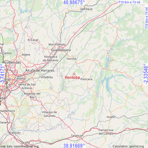
Hontoba GPS coordinates[2]
40° 27' 13.86" North, 3° 2' 18.888" West
| Map corner | latitude | longitude |
|---|---|---|
| Upper-left | 40.98675°, | -3.74171° |
| Center: | 40.45385°, | -3.03858° |
| Lower-right: | 39.91669°, | -2.33546° |
| Map W x H: | 119×119 km | = 73.9×73.9mi |
| max Lat: | 43.74134° ⇑62.9% North |
| Hontoba: | 40.45385° |
| min Lat: | ⇓37.1% South 27.64134° |
| min Long | Hontoba | max Long |
| -18.00367° | -3.03858° | 4.2899° |
| W 53.8%⇐ | ⇒46.2% E |
Elevation
Elevation of Hontoba is 761 m = 2497 ft, and this is 163 m = 535 ft above average elevation for this country.
| Max E: |
1682 m = 5518 ft | 37.5% |
| Hontoba | 761 m 2497 ft | |
| Avg. | 598 m = 1962 ft | |
Min E: |
0 m = 0 ft | 62.5% |
See also: Spain elevation on elevation.city.
Geographical zone
Hontoba is located in North temperate zone (between Tropic of Cancer and the Arctic Circle). Distance of this Northern Tropic circle is 1892.1 km =1175.7 mi to South.| Distance of | km | miles | from Hontoba |
|---|---|---|---|
| North Pole | 5509 | 3423.1 | to North |
| Arctic Circle | 2903.1 | 1803.9 | to North |
| Tropic Cancer | 1892.1 | 1175.7 | to South |
| Equator | 4498 | 2794.9 | to South |


Nearby cities:
15 places around Hontoba: (largest is in red/bold)
• Aranzueque
5.1 km =3.2 mi,  323°
323°
• Armuña de Tajuña
8.4 km =5.2 mi,  6°
6°
• Escariche
5.5 km =3.4 mi,  192°
192°
• Escopete
5.4 km =3.4 mi,  147°
147°
• Fuentelviejo
9.3 km =5.8 mi,  29°
29°
• Fuentenovilla
11.1 km =6.9 mi,  203°
203°
• Hueva
6.7 km =4.2 mi,  82°
82°
• Loranca de Tajuña
6.2 km =3.9 mi,  259°
259°
• Moratilla de los Meleros
9.7 km =6 mi,  56°
56°
• Pastrana
10.6 km =6.6 mi,  111°
111°
• Pioz
11.3 km =7 mi,  274°
274°
• Renera
4.5 km =2.8 mi, 27°
• Tendilla
12.1 km =7.5 mi, 34°
• Valdarachas
10.2 km =6.3 mi,  313°
313°
• Yebes
10.4 km =6.5 mi,  325°
325°
Sources, notices
• [Note1] Compared only with cities in Spain existing in our database
• [Src1] Map data: © OpenStreetMap contributors (CC-BY-SA)
• [Src2] Other city data from geonames.org with taken over terms of usage.
• [Src3] Geographical zone / Annual Mean Temperature by Robert A. Rohde @ Wikipedia
