Tendilla geodata
Tendilla (Castille-La Mancha) is a seat of a third-order administrative division; located in Spain in Europe/Madrid (GMT+2) time zone. With population of 345 people, there are 4330 cities with bigger population in this country. Compared to other cities in Spain, 61% of cities are located further ↑North; 55.2% of cities are located further ←West and 67.3% of cities have lower elevation than Tendilla. Note1
Administrative division(s):
- Level 1: Castille-La Mancha
- Level 2: Provincia de Guadalajara
- Level 3: Tendilla


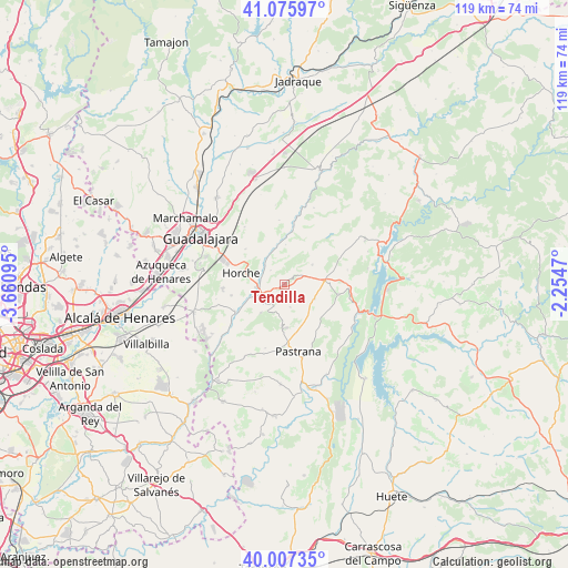
Tendilla GPS coordinates[2]
40° 32' 37.644" North, 2° 57' 28.152" West
| Map corner | latitude | longitude |
|---|---|---|
| Upper-left | 41.07597°, | -3.66095° |
| Center: | 40.54379°, | -2.95782° |
| Lower-right: | 40.00735°, | -2.2547° |
| Map W x H: | 118.8×118.8 km | = 73.8×73.8mi |
| max Lat: | 43.74134° ⇑61% North |
| Tendilla: | 40.54379° |
| min Lat: | ⇓39% South 27.64134° |
| min Long | Tendilla | max Long |
| -18.00367° | -2.95782° | 4.2899° |
| W 55.2%⇐ | ⇒44.8% E |
Elevation
Elevation of Tendilla is 794 m = 2605 ft, and this is 196 m = 643 ft above average elevation for this country.
| Max E: |
1682 m = 5518 ft | 32.7% |
| Tendilla | 794 m 2605 ft | |
| Avg. | 598 m = 1962 ft | |
Min E: |
0 m = 0 ft | 67.3% |
See also: Spain elevation on elevation.city.
Geographical zone
Tendilla is located in North temperate zone (between Tropic of Cancer and the Arctic Circle). Distance of this Northern Tropic circle is 1902.1 km =1181.9 mi to South.| Distance of | km | miles | from Tendilla |
|---|---|---|---|
| North Pole | 5499 | 3416.9 | to North |
| Arctic Circle | 2893.1 | 1797.7 | to North |
| Tropic Cancer | 1902.1 | 1181.9 | to South |
| Equator | 4508 | 2801.1 | to South |


Nearby cities:
15 places around Tendilla: (largest is in red/bold)
• Alhóndiga
11.4 km =7.1 mi,  99°
99°
• Aranzueque
11.5 km =7.1 mi,  239°
239°
• Armuña de Tajuña
6.2 km =3.9 mi,  254°
254°
• Fuentelencina
7 km =4.3 mi,  114°
114°
• Fuentelviejo
3 km =1.9 mi,  229°
229°
• Horche
9 km =5.6 mi,  284°
284°
• Hueva
9.1 km =5.7 mi,  181°
181°
• Irueste
9.5 km =5.9 mi,  36°
36°
• Lupiana
10.7 km =6.6 mi,  312°
312°
• Moratilla de los Meleros
4.8 km =3 mi,  164°
164°
• Peñalver
7.2 km =4.5 mi,  54°
54°
• Renera
7.6 km =4.7 mi,  218°
218°
• Romanones
4.1 km =2.5 mi,  317°
317°
• Valdeconcha
11.9 km =7.4 mi,  144°
144°
• Valfermoso de Tajuña
8.4 km =5.2 mi,  2°
2°
Sources, notices
• [Note1] Compared only with cities in Spain existing in our database
• [Src1] Map data: © OpenStreetMap contributors (CC-BY-SA)
• [Src2] Other city data from geonames.org with taken over terms of usage.
• [Src3] Geographical zone / Annual Mean Temperature by Robert A. Rohde @ Wikipedia
