Lanzahita geodata
Lanzahita (Castille and León) is a populated place; located in Spain in Europe/Madrid (GMT+2) time zone. With population of 993 people, there are 2957 cities with bigger population in this country. Compared to other cities in Spain, 67.1% of cities are located further ↑North; 71.7% of cities are located further →East and 65.5% of cities have higher elevation than Lanzahita. Note1
Administrative division(s):
- Level 1: Castille and León
- Level 2: Provincia de Ávila
- Level 3: Lanzahíta


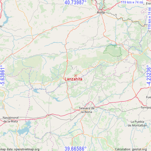
Lanzahita GPS coordinates[2]
40° 12' 17.964" North, 4° 56' 7.728" West
| Map corner | latitude | longitude |
|---|---|---|
| Upper-left | 40.73987°, | -5.63861° |
| Center: | 40.20499°, | -4.93548° |
| Lower-right: | 39.66586°, | -4.23236° |
| Map W x H: | 119.4×119.4 km | = 74.2×74.2mi |
| max Lat: | 43.74134° ⇑67.1% North |
| Lanzahita: | 40.20499° |
| min Lat: | ⇓32.9% South 27.64134° |
| min Long | Lanzahita | max Long |
| -18.00367° | -4.93548° | 4.2899° |
| W 28.3%⇐ | ⇒71.7% E |
Elevation
Elevation of Lanzahita is 454 m = 1490 ft, and this is 144 m = 472 ft below average elevation for this country.
| Max E: |
1682 m = 5518 ft | 65.5% |
| Avg. | 598 m = 1962 ft | |
| Lanzahita | 454 m = 1490 ft | |
Min E: |
0 m = 0 ft | 34.5% |
See also: Spain elevation on elevation.city.
Geographical zone
Lanzahita is located in North temperate zone (between Tropic of Cancer and the Arctic Circle). Distance of this Northern Tropic circle is 1864.5 km =1158.5 mi to South.| Distance of | km | miles | from Lanzahita |
|---|---|---|---|
| North Pole | 5536.7 | 3440.3 | to North |
| Arctic Circle | 2930.8 | 1821.1 | to North |
| Tropic Cancer | 1864.5 | 1158.5 | to South |
| Equator | 4470.4 | 2777.8 | to South |


Nearby cities:
15 places around Lanzahita: (largest is in red/bold)
• Arenas de San Pedro
12.9 km =8 mi,  272°
272°
• Buenaventura
7.9 km =4.9 mi,  113°
113°
• Cuevas del Valle
11.7 km =7.3 mi,  327°
327°
• Gavilanes
10.7 km =6.6 mi,  40°
40°
• Mijares
13.2 km =8.2 mi, 39°
• Mombeltrán
9.3 km =5.8 mi,  311°
311°
• Montesclaros
11 km =6.8 mi,  181°
181°
• Navamorcuende
13.8 km =8.6 mi, 113°
• Pedro Bernardo
4.7 km =2.9 mi,  27°
27°
• San Esteban del Valle
8.7 km =5.4 mi, 333°
• Santa Cruz del Valle
7.6 km =4.7 mi, 312°
• Sartajada
12 km =7.5 mi,  85°
85°
• Serranillos
14.7 km =9.1 mi,  7°
7°
• Sotillo de las Palomas
14.5 km =9 mi,  140°
140°
• Villarejo del Valle
10.4 km =6.5 mi, 330°
Sources, notices
• [Note1] Compared only with cities in Spain existing in our database
• [Src1] Map data: © OpenStreetMap contributors (CC-BY-SA)
• [Src2] Other city data from geonames.org with taken over terms of usage.
• [Src3] Geographical zone / Annual Mean Temperature by Robert A. Rohde @ Wikipedia
