Navalcán geodata
Navalcán (Castille-La Mancha) is a seat of a third-order administrative division; located in Spain in Europe/Madrid (GMT+2) time zone. With population of 2,227 people, there are 2037 cities with bigger population in this country. Compared to other cities in Spain, 69.2% of cities are located further ↑North; 73.6% of cities are located further →East and 68.6% of cities have higher elevation than Navalcán. Note1
Administrative division(s):
- Level 1: Castille-La Mancha
- Level 2: Province of Toledo
- Level 3: Navalcán


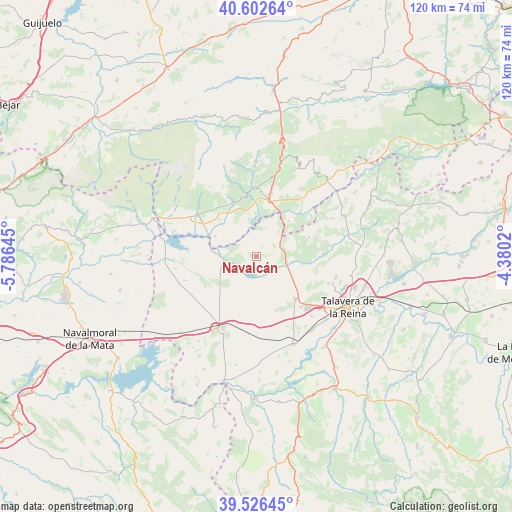
Navalcán GPS coordinates[2]
40° 4' 0.012" North, 5° 4' 59.988" West
| Map corner | latitude | longitude |
|---|---|---|
| Upper-left | 40.60264°, | -5.78645° |
| Center: | 40.06667°, | -5.08333° |
| Lower-right: | 39.52645°, | -4.3802° |
| Map W x H: | 119.7×119.7 km | = 74.4×74.4mi |
| max Lat: | 43.74134° ⇑69.2% North |
| Navalcán: | 40.06667° |
| min Lat: | ⇓30.8% South 27.64134° |
| min Long | Navalcán | max Long |
| -18.00367° | -5.08333° | 4.2899° |
| W 26.4%⇐ | ⇒73.6% E |
Elevation
Elevation of Navalcán is 405 m = 1329 ft, and this is 193 m = 633 ft below average elevation for this country.
| Max E: |
1682 m = 5518 ft | 68.6% |
| Avg. | 598 m = 1962 ft | |
| Navalcán | 405 m = 1329 ft | |
Min E: |
0 m = 0 ft | 31.4% |
See also: Spain elevation on elevation.city.
Geographical zone
Navalcán is located in North temperate zone (between Tropic of Cancer and the Arctic Circle). Distance of this Northern Tropic circle is 1849.1 km =1149 mi to South.| Distance of | km | miles | from Navalcán |
|---|---|---|---|
| North Pole | 5552.1 | 3449.9 | to North |
| Arctic Circle | 2946.2 | 1830.7 | to North |
| Tropic Cancer | 1849.1 | 1149 | to South |
| Equator | 4455 | 2768.2 | to South |


Nearby cities:
15 places around Navalcán: (largest is in red/bold)
• Alcañizo
18.3 km =11.4 mi,  186°
186°
• Arenas de San Pedro
16 km =9.9 mi,  358°
358°
• Candeleda
16.6 km =10.3 mi,  306°
306°
• Gamonal
15.7 km =9.8 mi,  138°
138°
• Guisando
17.9 km =11.1 mi,  344°
344°
• Lagartera
20.5 km =12.7 mi,  209°
209°
• Lanzahita
19.9 km =12.4 mi,  39°
39°
• Mejorada
18 km =11.2 mi,  110°
110°
• Montesclaros
13.1 km =8.1 mi,  70°
70°
• Oropesa
18.3 km =11.4 mi,  204°
204°
• Parrillas
1.7 km =1.1 mi, 106°
• Poyales del Hoyo
13.7 km =8.5 mi,  329°
329°
• Segurilla
19.3 km =12 mi,  104°
104°
• Torralba de Oropesa
16 km =9.9 mi, 202°
• Velada
13.5 km =8.4 mi, 137°
Sources, notices
• [Note1] Compared only with cities in Spain existing in our database
• [Src1] Map data: © OpenStreetMap contributors (CC-BY-SA)
• [Src2] Other city data from geonames.org with taken over terms of usage.
• [Src3] Geographical zone / Annual Mean Temperature by Robert A. Rohde @ Wikipedia
