Granera geodata
Granera (Catalonia) is a seat of a third-order administrative division; located in Spain in Europe/Madrid (GMT+2) time zone. With population of 80 people, there are 6136 cities with bigger population in this country. Compared to other cities in Spain, 66.7% of cities are located further ↓South; 93.7% of cities are located further ←West and 64.4% of cities have lower elevation than Granera. Note1


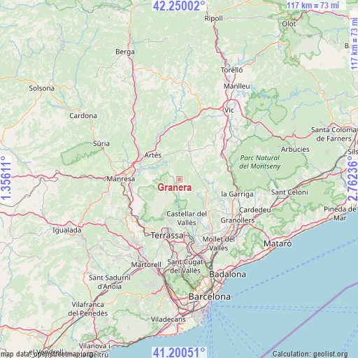
Granera GPS coordinates[2]
41° 43' 38.676" North, 2° 3' 33.264" East
| Map corner | latitude | longitude |
|---|---|---|
| Upper-left | 42.25002°, | 1.35611° |
| Center: | 41.72741°, | 2.05924° |
| Lower-right: | 41.20051°, | 2.76236° |
| Map W x H: | 116.7×116.7 km | = 72.5×72.5mi |
| max Lat: | 43.74134° ⇑33.3% North |
| Granera: | 41.72741° |
| min Lat: | ⇓66.7% South 27.64134° |
| min Long | Granera | max Long |
| -18.00367° | 2.05924° | 4.2899° |
| W 93.7%⇐ | ⇒6.3% E |
Elevation
Elevation of Granera is 774 m = 2539 ft, and this is 176 m = 577 ft above average elevation for this country.
| Max E: |
1682 m = 5518 ft | 35.6% |
| Granera | 774 m 2539 ft | |
| Avg. | 598 m = 1962 ft | |
Min E: |
0 m = 0 ft | 64.4% |
See also: Spain elevation on elevation.city.
Geographical zone
Granera is located in North temperate zone (between Tropic of Cancer and the Arctic Circle). Distance of this Northern Tropic circle is 2033.7 km =1263.7 mi to South.| Distance of | km | miles | from Granera |
|---|---|---|---|
| North Pole | 5367.4 | 3335.1 | to North |
| Arctic Circle | 2761.5 | 1715.9 | to North |
| Tropic Cancer | 2033.7 | 1263.7 | to South |
| Equator | 4639.7 | 2883 | to South |


Nearby cities:
15 places around Granera: (largest is in red/bold)
• Artés
11.7 km =7.3 mi,  312°
312°
• Calders
9.1 km =5.7 mi,  318°
318°
• Caldes de Montbui
13.7 km =8.5 mi,  139°
139°
• Castellar del Vallès
12.5 km =7.8 mi,  170°
170°
• Castellcir
9.2 km =5.7 mi,  66°
66°
• Castellterçol
5.4 km =3.4 mi,  62°
62°
• Gallifa
5.9 km =3.7 mi,  130°
130°
• Moià
9.9 km =6.2 mi,  19°
19°
• Monistrol de Calders
5.1 km =3.2 mi, 316°
• Mura
7.6 km =4.7 mi,  245°
245°
• Navarcles
13.2 km =8.2 mi,  281°
281°
• Sant Feliu de Codines
9.4 km =5.8 mi,  108°
108°
• Sant Martí de Centelles
12.9 km =8 mi, 70°
• Sant Quirze Safaja
7.6 km =4.7 mi,  85°
85°
• Talamanca
6.8 km =4.2 mi, 279°
Sources, notices
• [Note1] Compared only with cities in Spain existing in our database
• [Src1] Map data: © OpenStreetMap contributors (CC-BY-SA)
• [Src2] Other city data from geonames.org with taken over terms of usage.
• [Src3] Geographical zone / Annual Mean Temperature by Robert A. Rohde @ Wikipedia
