Castellterçol geodata
Castellterçol (Catalonia) is a seat of a third-order administrative division; located in Spain in Europe/Madrid (GMT+2) time zone. In our database, there are 6762 cities with bigger population. Compared to other cities in Spain, 67.3% of cities are located further ↓South; 94% of cities are located further ←West and 57.6% of cities have lower elevation than Castellterçol. Note1
Administrative division(s):
- Level 1: Catalonia
- Level 2: Província de Barcelona
- Level 3: Castellterçol


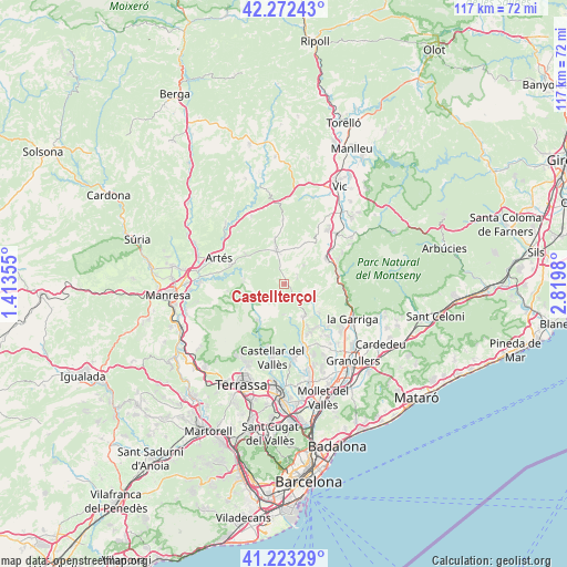
Castellterçol GPS coordinates[2]
41° 45' 0" North, 2° 7' 0.012" East
| Map corner | latitude | longitude |
|---|---|---|
| Upper-left | 42.27243°, | 1.41355° |
| Center: | 41.75°, | 2.11667° |
| Lower-right: | 41.22329°, | 2.8198° |
| Map W x H: | 116.7×116.7 km | = 72.5×72.5mi |
| max Lat: | 43.74134° ⇑32.7% North |
| Castellterçol: | 41.75° |
| min Lat: | ⇓67.3% South 27.64134° |
| min Long | Castellterçol | max Long |
| -18.00367° | 2.11667° | 4.2899° |
| W 94%⇐ | ⇒6% E |
Elevation
Elevation of Castellterçol is 727 m = 2385 ft, and this is 129 m = 423 ft above average elevation for this country.
| Max E: |
1682 m = 5518 ft | 42.4% |
| Castellterçol | 727 m 2385 ft | |
| Avg. | 598 m = 1962 ft | |
Min E: |
0 m = 0 ft | 57.6% |
See also: Spain elevation on elevation.city.
Geographical zone
Castellterçol is located in North temperate zone (between Tropic of Cancer and the Arctic Circle). Distance of this Northern Tropic circle is 2036.2 km =1265.2 mi to South.| Distance of | km | miles | from Castellterçol |
|---|---|---|---|
| North Pole | 5364.9 | 3333.6 | to North |
| Arctic Circle | 2759 | 1714.4 | to North |
| Tropic Cancer | 2036.2 | 1265.2 | to South |
| Equator | 4642.2 | 2884.5 | to South |


Nearby cities:
15 places around Castellterçol: (largest is in red/bold)
• Aiguafreda
11.3 km =7 mi,  79°
79°
• Bigues i Riells
12.2 km =7.6 mi,  127°
127°
• Calders
11.6 km =7.2 mi,  291°
291°
• Castellcir
3.9 km =2.4 mi,  72°
72°
• Centelles
10 km =6.2 mi,  58°
58°
• Collsuspina
9.7 km =6 mi,  30°
30°
• Gallifa
6.4 km =4 mi,  182°
182°
• Granera
5.4 km =3.4 mi,  242°
242°
• Moià
7 km =4.3 mi,  347°
347°
• Monistrol de Calders
8.4 km =5.2 mi,  277°
277°
• Sant Feliu de Codines
6.9 km =4.3 mi,  143°
143°
• Sant Martí de Centelles
7.6 km =4.7 mi, 76°
• Sant Quirze Safaja
3.3 km =2.1 mi,  123°
123°
• Tagamanent
12.6 km =7.8 mi,  96°
96°
• Talamanca
11.6 km =7.2 mi,  263°
263°
Sources, notices
• [Note1] Compared only with cities in Spain existing in our database
• [Src1] Map data: © OpenStreetMap contributors (CC-BY-SA)
• [Src2] Other city data from geonames.org with taken over terms of usage.
• [Src3] Geographical zone / Annual Mean Temperature by Robert A. Rohde @ Wikipedia
