Castellcir geodata
Castellcir (Catalonia) is a seat of a third-order administrative division; located in Spain in Europe/Madrid (GMT+2) time zone. With population of 546 people, there are 3749 cities with bigger population in this country. Compared to other cities in Spain, 67.6% of cities are located further ↓South; 94.5% of cities are located further ←West and 56.6% of cities have lower elevation than Castellcir. Note1


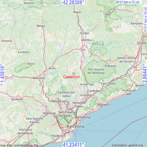
Castellcir GPS coordinates[2]
41° 45' 38.664" North, 2° 9' 40.608" East
| Map corner | latitude | longitude |
|---|---|---|
| Upper-left | 42.28308°, | 1.45816° |
| Center: | 41.76074°, | 2.16128° |
| Lower-right: | 41.23411°, | 2.86441° |
| Map W x H: | 116.6×116.6 km | = 72.5×72.5mi |
| max Lat: | 43.74134° ⇑32.4% North |
| Castellcir: | 41.76074° |
| min Lat: | ⇓67.6% South 27.64134° |
| min Long | Castellcir | max Long |
| -18.00367° | 2.16128° | 4.2899° |
| W 94.5%⇐ | ⇒5.5% E |
Elevation
Elevation of Castellcir is 720 m = 2362 ft, and this is 122 m = 400 ft above average elevation for this country.
| Max E: |
1682 m = 5518 ft | 43.4% |
| Castellcir | 720 m 2362 ft | |
| Avg. | 598 m = 1962 ft | |
Min E: |
0 m = 0 ft | 56.6% |
See also: Spain elevation on elevation.city.
Geographical zone
Castellcir is located in North temperate zone (between Tropic of Cancer and the Arctic Circle). Distance of this Northern Tropic circle is 2037.4 km =1266 mi to South.| Distance of | km | miles | from Castellcir |
|---|---|---|---|
| North Pole | 5363.7 | 3332.8 | to North |
| Arctic Circle | 2757.8 | 1713.6 | to North |
| Tropic Cancer | 2037.4 | 1266 | to South |
| Equator | 4643.4 | 2885.3 | to South |


Nearby cities:
15 places around Castellcir: (largest is in red/bold)
• Aiguafreda
7.4 km =4.6 mi,  83°
83°
• Bigues i Riells
10.5 km =6.5 mi,  145°
145°
• Castellterçol
3.9 km =2.4 mi,  252°
252°
• Centelles
6.3 km =3.9 mi,  49°
49°
• Collsuspina
7.3 km =4.5 mi,  9°
9°
• Figaró
10.3 km =6.4 mi,  115°
115°
• Gallifa
8.6 km =5.3 mi,  207°
207°
• Granera
9.2 km =5.7 mi, 246°
• Moià
7.7 km =4.8 mi,  317°
317°
• Monistrol de Calders
12 km =7.5 mi,  269°
269°
• Sant Feliu de Codines
6.8 km =4.2 mi,  176°
176°
• Sant Martí de Centelles
3.7 km =2.3 mi, 80°
• Sant Quirze Safaja
3.2 km =2 mi,  197°
197°
• Tagamanent
9.2 km =5.7 mi,  106°
106°
• Tona
11.2 km =7 mi,  29°
29°
Sources, notices
• [Note1] Compared only with cities in Spain existing in our database
• [Src1] Map data: © OpenStreetMap contributors (CC-BY-SA)
• [Src2] Other city data from geonames.org with taken over terms of usage.
• [Src3] Geographical zone / Annual Mean Temperature by Robert A. Rohde @ Wikipedia
