Garralda geodata
Garralda (Navarre) is a seat of a third-order administrative division; located in Spain in Europe/Madrid (GMT+2) time zone. With population of 190 people, there are 5108 cities with bigger population in this country. Compared to other cities in Spain, 94% of cities are located further ↓South; 74.9% of cities are located further ←West and 74.9% of cities have lower elevation than Garralda. Note1


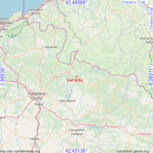
Garralda GPS coordinates[2]
42° 56' 53.448" North, 1° 17' 10.464" West
| Map corner | latitude | longitude |
|---|---|---|
| Upper-left | 43.46069°, | -1.98936° |
| Center: | 42.94818°, | -1.28624° |
| Lower-right: | 42.43136°, | -0.58311° |
| Map W x H: | 114.5×114.4 km | = 71.1×71.1mi |
| max Lat: | 43.74134° ⇑6% North |
| Garralda: | 42.94818° |
| min Lat: | ⇓94% South 27.64134° |
| min Long | Garralda | max Long |
| -18.00367° | -1.28624° | 4.2899° |
| W 74.9%⇐ | ⇒25.1% E |
Elevation
Elevation of Garralda is 850 m = 2789 ft, and this is 252 m = 827 ft above average elevation for this country.
| Max E: |
1682 m = 5518 ft | 25.1% |
| Garralda | 850 m 2789 ft | |
| Avg. | 598 m = 1962 ft | |
Min E: |
0 m = 0 ft | 74.9% |
See also: Spain elevation on elevation.city.
Geographical zone
Garralda is located in North temperate zone (between Tropic of Cancer and the Arctic Circle). Distance of this Northern Tropic circle is 2169.5 km =1348.1 mi to South.| Distance of | km | miles | from Garralda |
|---|---|---|---|
| North Pole | 5231.7 | 3250.8 | to North |
| Arctic Circle | 2625.8 | 1631.6 | to North |
| Tropic Cancer | 2169.5 | 1348.1 | to South |
| Equator | 4775.4 | 2967.3 | to South |


Nearby cities:
15 places around Garralda: (largest is in red/bold)
• Aoiz
19.3 km =12 mi,  201°
201°
• Aria
1.7 km =1.1 mi,  72°
72°
• Aribe
3 km =1.9 mi,  86°
86°
• Atarrabia
29.2 km =18.1 mi,  243°
243°
• Burlata
30.2 km =18.8 mi, 243°
• Erroibar
13.3 km =8.3 mi,  270°
270°
• Garaioa
4.6 km =2.9 mi,  110°
110°
• Huarte-Uharte
28.1 km =17.5 mi, 242°
• Lantz
27.5 km =17.1 mi,  282°
282°
• Lizoáin
22.2 km =13.8 mi,  221°
221°
• Navascués
29.1 km =18.1 mi,  151°
151°
• Ochagavía
16.6 km =10.3 mi, 106°
• Orbara
4.2 km =2.6 mi,  59°
59°
• Oronz
17.8 km =11.1 mi,  119°
119°
• Sarriguren
29.5 km =18.3 mi, 239°
Sources, notices
• [Note1] Compared only with cities in Spain existing in our database
• [Src1] Map data: © OpenStreetMap contributors (CC-BY-SA)
• [Src2] Other city data from geonames.org with taken over terms of usage.
• [Src3] Geographical zone / Annual Mean Temperature by Robert A. Rohde @ Wikipedia
