Atarrabia geodata
Atarrabia (Navarre) is a populated place; located in Spain in Europe/Madrid (GMT+2) time zone. With population of 10,341 people, there are 838 cities with bigger population in this country. Compared to other cities in Spain, 93% of cities are located further ↓South; 71.9% of cities are located further ←West and 66.8% of cities have higher elevation than Atarrabia. Note1


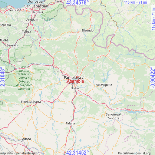
Atarrabia GPS coordinates[2]
42° 49' 56.28" North, 1° 36' 26.46" West
| Map corner | latitude | longitude |
|---|---|---|
| Upper-left | 43.34578°, | -2.31048° |
| Center: | 42.8323°, | -1.60735° |
| Lower-right: | 42.31452°, | -0.90422° |
| Map W x H: | 114.7×114.7 km | = 71.3×71.3mi |
| max Lat: | 43.74134° ⇑7% North |
| Atarrabia: | 42.8323° |
| min Lat: | ⇓93% South 27.64134° |
| min Long | Atarrabia | max Long |
| -18.00367° | -1.60735° | 4.2899° |
| W 71.9%⇐ | ⇒28.1% E |
Elevation
Elevation of Atarrabia is 436 m = 1430 ft, and this is 162 m = 531 ft below average elevation for this country.
| Max E: |
1682 m = 5518 ft | 66.8% |
| Avg. | 598 m = 1962 ft | |
| Atarrabia | 436 m = 1430 ft | |
Min E: |
0 m = 0 ft | 33.2% |
See also: Spain elevation on elevation.city.
Geographical zone
Atarrabia is located in North temperate zone (between Tropic of Cancer and the Arctic Circle). Distance of this Northern Tropic circle is 2156.6 km =1340 mi to South.| Distance of | km | miles | from Atarrabia |
|---|---|---|---|
| North Pole | 5244.6 | 3258.8 | to North |
| Arctic Circle | 2638.7 | 1639.6 | to North |
| Tropic Cancer | 2156.6 | 1340 | to South |
| Equator | 4762.5 | 2959.3 | to South |


Nearby cities:
15 places around Atarrabia: (largest is in red/bold)
• Barañáin
6.4 km =4 mi,  242°
242°
• Berriobeiti
7.8 km =4.8 mi,  284°
284°
• Berriozar
4.8 km =3 mi,  267°
267°
• Burlata
1.1 km =0.7 mi,  225°
225°
• Cizur Mayor
8.4 km =5.2 mi, 234°
• Ermitagaña
5.2 km =3.2 mi, 242°
• Galar
10.8 km =6.7 mi,  223°
223°
• Huarte-Uharte
1.4 km =0.9 mi,  99°
99°
• Iturrama
4.9 km =3 mi, 237°
• Itza
10 km =6.2 mi, 272°
• Orkoien
8 km =5 mi,  263°
263°
• Pamplona
3.4 km =2.1 mi, 239°
• Primer Ensanche
3.9 km =2.4 mi, 240°
• Sarriguren
2.3 km =1.4 mi,  160°
160°
• Segundo Ensanche
3.6 km =2.2 mi, 234°
Sources, notices
• [Note1] Compared only with cities in Spain existing in our database
• [Src1] Map data: © OpenStreetMap contributors (CC-BY-SA)
• [Src2] Other city data from geonames.org with taken over terms of usage.
• [Src3] Geographical zone / Annual Mean Temperature by Robert A. Rohde @ Wikipedia
