Sarriguren geodata
Sarriguren (Navarre) is a seat of a third-order administrative division; located in Spain in Europe/Madrid (GMT+2) time zone. With population of 14,779 people, there are 627 cities with bigger population in this country. Compared to other cities in Spain, 92.8% of cities are located further ↓South; 72.1% of cities are located further ←West and 65% of cities have higher elevation than Sarriguren. Note1


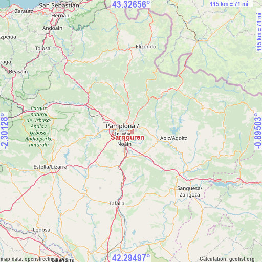
Sarriguren GPS coordinates[2]
42° 48' 46.512" North, 1° 35' 53.34" West
| Map corner | latitude | longitude |
|---|---|---|
| Upper-left | 43.32656°, | -2.30128° |
| Center: | 42.81292°, | -1.59815° |
| Lower-right: | 42.29497°, | -0.89503° |
| Map W x H: | 114.7×114.7 km | = 71.3×71.3mi |
| max Lat: | 43.74134° ⇑7.2% North |
| Sarriguren: | 42.81292° |
| min Lat: | ⇓92.8% South 27.64134° |
| min Long | Sarriguren | max Long |
| -18.00367° | -1.59815° | 4.2899° |
| W 72.1%⇐ | ⇒27.9% E |
Elevation
Elevation of Sarriguren is 460 m = 1509 ft, and this is 138 m = 453 ft below average elevation for this country.
| Max E: |
1682 m = 5518 ft | 65% |
| Avg. | 598 m = 1962 ft | |
| Sarriguren | 460 m = 1509 ft | |
Min E: |
0 m = 0 ft | 35% |
See also: Spain elevation on elevation.city.
Geographical zone
Sarriguren is located in North temperate zone (between Tropic of Cancer and the Arctic Circle). Distance of this Northern Tropic circle is 2154.4 km =1338.7 mi to South.| Distance of | km | miles | from Sarriguren |
|---|---|---|---|
| North Pole | 5246.7 | 3260.1 | to North |
| Arctic Circle | 2640.8 | 1640.9 | to North |
| Tropic Cancer | 2154.4 | 1338.7 | to South |
| Equator | 4760.4 | 2958 | to South |


Nearby cities:
15 places around Sarriguren: (largest is in red/bold)
• Atarrabia
2.3 km =1.4 mi,  340°
340°
• Barañáin
6.5 km =4 mi,  262°
262°
• Beriáin
9.6 km =6 mi,  203°
203°
• Berriobeiti
9.3 km =5.8 mi,  296°
296°
• Berriozar
5.9 km =3.7 mi,  289°
289°
• Burlata
2.1 km =1.3 mi,  313°
313°
• Cizur Mayor
8 km =5 mi,  249°
249°
• Elorz
9.4 km =5.8 mi,  161°
161°
• Ermitagaña
5.4 km =3.4 mi,  267°
267°
• Huarte-Uharte
2 km =1.2 mi,  17°
17°
• Iturrama
4.9 km =3 mi, 264°
• Orkoien
8.8 km =5.5 mi,  277°
277°
• Pamplona
3.7 km =2.3 mi, 276°
• Primer Ensanche
4.2 km =2.6 mi, 272°
• Segundo Ensanche
3.7 km =2.3 mi, 271°
Sources, notices
• [Note1] Compared only with cities in Spain existing in our database
• [Src1] Map data: © OpenStreetMap contributors (CC-BY-SA)
• [Src2] Other city data from geonames.org with taken over terms of usage.
• [Src3] Geographical zone / Annual Mean Temperature by Robert A. Rohde @ Wikipedia
