Alcanadre geodata
Alcanadre (La Rioja) is a seat of a third-order administrative division; located in Spain in Europe/Madrid (GMT+2) time zone. With population of 754 people, there are 3297 cities with bigger population in this country. Compared to other cities in Spain, 84.9% of cities are located further ↓South; 65.9% of cities are located further ←West and 71.9% of cities have higher elevation than Alcanadre. Note1


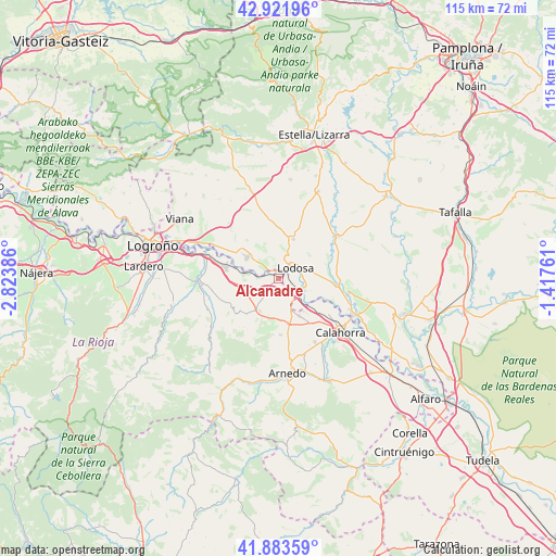
Alcanadre GPS coordinates[2]
42° 24' 17.712" North, 2° 7' 14.628" West
| Map corner | latitude | longitude |
|---|---|---|
| Upper-left | 42.92196°, | -2.82386° |
| Center: | 42.40492°, | -2.12073° |
| Lower-right: | 41.88359°, | -1.41761° |
| Map W x H: | 115.5×115.5 km | = 71.8×71.8mi |
| max Lat: | 43.74134° ⇑15.1% North |
| Alcanadre: | 42.40492° |
| min Lat: | ⇓84.9% South 27.64134° |
| min Long | Alcanadre | max Long |
| -18.00367° | -2.12073° | 4.2899° |
| W 65.9%⇐ | ⇒34.1% E |
Elevation
Elevation of Alcanadre is 348 m = 1142 ft, and this is 250 m = 820 ft below average elevation for this country.
| Max E: |
1682 m = 5518 ft | 71.9% |
| Avg. | 598 m = 1962 ft | |
| Alcanadre | 348 m = 1142 ft | |
Min E: |
0 m = 0 ft | 28.1% |
See also: Spain elevation on elevation.city.
Geographical zone
Alcanadre is located in North temperate zone (between Tropic of Cancer and the Arctic Circle). Distance of this Northern Tropic circle is 2109.1 km =1310.5 mi to South.| Distance of | km | miles | from Alcanadre |
|---|---|---|---|
| North Pole | 5292.1 | 3288.4 | to North |
| Arctic Circle | 2686.2 | 1669.1 | to North |
| Tropic Cancer | 2109.1 | 1310.5 | to South |
| Equator | 4715 | 2929.8 | to South |


Nearby cities:
15 places around Alcanadre: (largest is in red/bold)
• Agoncillo
14.6 km =9.1 mi,  288°
288°
• Andosilla
14.9 km =9.3 mi,  101°
101°
• Arrúbal
11.2 km =7 mi, 287°
• Ausejo
8 km =5 mi,  208°
208°
• Corera
10.7 km =6.6 mi,  230°
230°
• Cárcar
11.7 km =7.3 mi, 96°
• El Villar de Arnedo
9.6 km =6 mi,  167°
167°
• Galilea
11.5 km =7.1 mi,  235°
235°
• Lazagurría
13.8 km =8.6 mi,  314°
314°
• Lodosa
4.1 km =2.5 mi,  60°
60°
• Mendavia
7.8 km =4.8 mi,  303°
303°
• Pradejón
8.9 km =5.5 mi,  151°
151°
• Sartaguda
5.8 km =3.6 mi,  114°
114°
• Sesma
8.6 km =5.3 mi,  20°
20°
• Tudelilla
11.6 km =7.2 mi,  178°
178°
Sources, notices
• [Note1] Compared only with cities in Spain existing in our database
• [Src1] Map data: © OpenStreetMap contributors (CC-BY-SA)
• [Src2] Other city data from geonames.org with taken over terms of usage.
• [Src3] Geographical zone / Annual Mean Temperature by Robert A. Rohde @ Wikipedia
