El Villar de Arnedo geodata
El Villar de Arnedo (La Rioja) is a populated place; located in Spain in Europe/Madrid (GMT+2) time zone. With population of 639 people, there are 3524 cities with bigger population in this country. Compared to other cities in Spain, 82.4% of cities are located further ↓South; 66.2% of cities are located further ←West and 66.9% of cities have higher elevation than El Villar de Arnedo. Note1
Administrative division(s):
- Level 1: La Rioja
- Level 2: Provincia de La Rioja
- Level 3: Villar de Arnedo, El


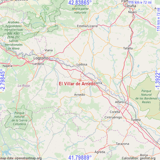
El Villar de Arnedo GPS coordinates[2]
42° 19' 15.312" North, 2° 5' 43.188" West
| Map corner | latitude | longitude |
|---|---|---|
| Upper-left | 42.83865°, | -2.79845° |
| Center: | 42.32092°, | -2.09533° |
| Lower-right: | 41.79889°, | -1.3922° |
| Map W x H: | 115.6×115.6 km | = 71.8×71.8mi |
| max Lat: | 43.74134° ⇑17.6% North |
| El Villar de Arnedo: | 42.32092° |
| min Lat: | ⇓82.4% South 27.64134° |
| min Long | El Villar de Ar | max Long |
| -18.00367° | -2.09533° | 4.2899° |
| W 66.2%⇐ | ⇒33.8% E |
Elevation
Elevation of El Villar de Arnedo is 435 m = 1427 ft, and this is 163 m = 535 ft below average elevation for this country.
| Max E: |
1682 m = 5518 ft | 66.9% |
| Avg. | 598 m = 1962 ft | |
| El Villar de Arnedo | 435 m = 1427 ft | |
Min E: |
0 m = 0 ft | 33.1% |
See also: Spain elevation on elevation.city.
Geographical zone
El Villar de Arnedo is located in North temperate zone (between Tropic of Cancer and the Arctic Circle). Distance of this Northern Tropic circle is 2099.7 km =1304.7 mi to South.| Distance of | km | miles | from El Villar de Arnedo |
|---|---|---|---|
| North Pole | 5301.4 | 3294.1 | to North |
| Arctic Circle | 2695.5 | 1674.9 | to North |
| Tropic Cancer | 2099.7 | 1304.7 | to South |
| Equator | 4705.6 | 2923.9 | to South |


Nearby cities:
15 places around El Villar de Arnedo: (largest is in red/bold)
• Alcanadre
9.6 km =6 mi,  347°
347°
• Arnedo
10.3 km =6.4 mi,  182°
182°
• Ausejo
6.4 km =4 mi,  291°
291°
• Bergasa
8.2 km =5.1 mi,  201°
201°
• Bergasillas Bajera
9.9 km =6.2 mi,  211°
211°
• Calahorra
10.8 km =6.7 mi,  99°
99°
• Corera
10.6 km =6.6 mi,  283°
283°
• Cárcar
12.5 km =7.8 mi,  49°
49°
• Galilea
11.9 km =7.4 mi, 284°
• Lodosa
11.4 km =7.1 mi,  7°
7°
• Ocón
12.2 km =7.6 mi,  258°
258°
• Pradejón
2.7 km =1.7 mi,  55°
55°
• Quel
10.7 km =6.6 mi,  160°
160°
• Sartaguda
7.6 km =4.7 mi,  24°
24°
• Tudelilla
2.9 km =1.8 mi,  218°
218°
Sources, notices
• [Note1] Compared only with cities in Spain existing in our database
• [Src1] Map data: © OpenStreetMap contributors (CC-BY-SA)
• [Src2] Other city data from geonames.org with taken over terms of usage.
• [Src3] Geographical zone / Annual Mean Temperature by Robert A. Rohde @ Wikipedia
