Robres del Castillo geodata
Robres del Castillo (La Rioja) is a seat of a third-order administrative division; located in Spain in Europe/Madrid (GMT+2) time zone. With population of 39 people, there are 6576 cities with bigger population in this country. Compared to other cities in Spain, 81.3% of cities are located further ↓South; 63.6% of cities are located further ←West and 57.4% of cities have lower elevation than Robres del Castillo. Note1
Administrative division(s):
- Level 1: La Rioja
- Level 2: Provincia de La Rioja
- Level 3: Robres del Castillo


Robres del Castillo GPS coordinates[2]
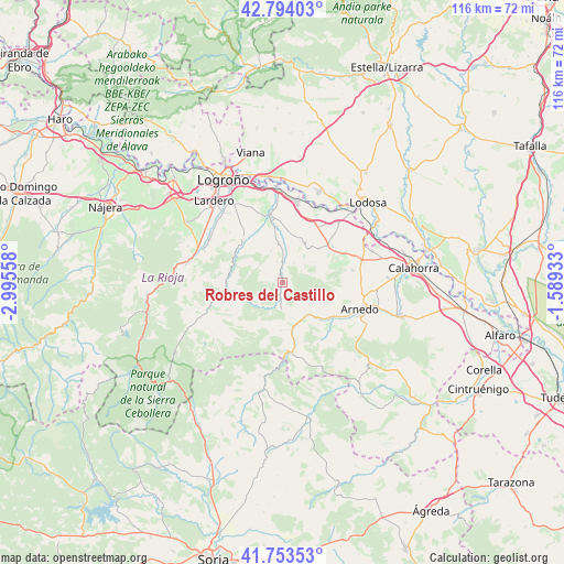
42° 16' 33.348" North, 2° 17' 32.82" West
| Map corner | latitude | longitude |
|---|---|---|
| Upper-left | 42.79403°, | -2.99558° |
| Center: | 42.27593°, | -2.29245° |
| Lower-right: | 41.75353°, | -1.58933° |
| Map W x H: | 115.7×115.7 km | = 71.9×71.9mi |
| max Lat: | 43.74134° ⇑18.7% North |
| Robres del Castillo: | 42.27593° |
| min Lat: | ⇓81.3% South 27.64134° |
| min Long | Robres del Cast | max Long |
| -18.00367° | -2.29245° | 4.2899° |
| W 63.6%⇐ | ⇒36.4% E |
Elevation
Elevation of Robres del Castillo is 726 m = 2382 ft, and this is 128 m = 420 ft above average elevation for this country.
| Max E: |
1682 m = 5518 ft | 42.6% |
| Robres del Castillo | 726 m 2382 ft | |
| Avg. | 598 m = 1962 ft | |
Min E: |
0 m = 0 ft | 57.4% |
See also: Spain elevation on elevation.city.
Geographical zone
Robres del Castillo is located in North temperate zone (between Tropic of Cancer and the Arctic Circle). Distance of this Northern Tropic circle is 2094.7 km =1301.6 mi to South.| Distance of | km | miles | from Robres del Castillo |
|---|---|---|---|
| North Pole | 5306.4 | 3297.2 | to North |
| Arctic Circle | 2700.5 | 1678 | to North |
| Tropic Cancer | 2094.7 | 1301.6 | to South |
| Equator | 4700.6 | 2920.8 | to South |


Nearby cities:
15 places around Robres del Castillo: (largest is in red/bold)
• Arnedillo
8.5 km =5.3 mi,  146°
146°
• Ausejo
12.7 km =7.9 mi,  54°
54°
• Bergasillas Bajera
11.6 km =7.2 mi,  107°
107°
• Corera
9.6 km =6 mi,  38°
38°
• Galilea
9.2 km =5.7 mi,  30°
30°
• Herce
12.5 km =7.8 mi,  123°
123°
• Lagunilla del Jubera
6.9 km =4.3 mi,  339°
339°
• Leza de Río Leza
11.1 km =6.9 mi,  302°
302°
• Munilla
9.7 km =6 mi,  181°
181°
• Ocón
5 km =3.1 mi,  59°
59°
• Ribafrecha
11.9 km =7.4 mi,  317°
317°
• Santa Eulalia Bajera
11.1 km =6.9 mi,  131°
131°
• Soto en Cameros
11 km =6.8 mi,  275°
275°
• Terroba
12.6 km =7.8 mi,  260°
260°
• Zarzosa
11.1 km =6.9 mi,  201°
201°
Sources, notices
• [Note1] Compared only with cities in Spain existing in our database
• [Src1] Map data: © OpenStreetMap contributors (CC-BY-SA)
• [Src2] Other city data from geonames.org with taken over terms of usage.
• [Src3] Geographical zone / Annual Mean Temperature by Robert A. Rohde @ Wikipedia
