Fuendetodos geodata
Fuendetodos (Aragon) is a seat of a third-order administrative division; located in Spain in Europe/Madrid (GMT+2) time zone. With population of 175 people, there are 5220 cities with bigger population in this country. Compared to other cities in Spain, 56.1% of cities are located further ↓South; 77.5% of cities are located further ←West and 61.6% of cities have lower elevation than Fuendetodos. Note1


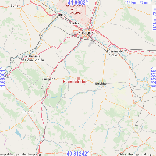
Fuendetodos GPS coordinates[2]
41° 20' 32.82" North, 0° 57' 35.568" West
| Map corner | latitude | longitude |
|---|---|---|
| Upper-left | 41.8682°, | -1.66301° |
| Center: | 41.34245°, | -0.95988° |
| Lower-right: | 40.81242°, | -0.25675° |
| Map W x H: | 117.4×117.4 km | = 72.9×72.9mi |
| max Lat: | 43.74134° ⇑43.9% North |
| Fuendetodos: | 41.34245° |
| min Lat: | ⇓56.1% South 27.64134° |
| min Long | Fuendetodos | max Long |
| -18.00367° | -0.95988° | 4.2899° |
| W 77.5%⇐ | ⇒22.5% E |
Elevation
Elevation of Fuendetodos is 755 m = 2477 ft, and this is 157 m = 515 ft above average elevation for this country.
| Max E: |
1682 m = 5518 ft | 38.4% |
| Fuendetodos | 755 m 2477 ft | |
| Avg. | 598 m = 1962 ft | |
Min E: |
0 m = 0 ft | 61.6% |
See also: Spain elevation on elevation.city.
Geographical zone
Fuendetodos is located in North temperate zone (between Tropic of Cancer and the Arctic Circle). Distance of this Northern Tropic circle is 1990.9 km =1237.1 mi to South.| Distance of | km | miles | from Fuendetodos |
|---|---|---|---|
| North Pole | 5410.2 | 3361.7 | to North |
| Arctic Circle | 2804.3 | 1742.5 | to North |
| Tropic Cancer | 1990.9 | 1237.1 | to South |
| Equator | 4596.8 | 2856.3 | to South |


Nearby cities:
15 places around Fuendetodos: (largest is in red/bold)
• Aguilón
9 km =5.6 mi,  233°
233°
• Almonacid de la Cuba
15.6 km =9.7 mi,  116°
116°
• Azuara
12 km =7.5 mi,  141°
141°
• Belchite
17.7 km =11 mi,  103°
103°
• Herrera de los Navarros
17.9 km =11.1 mi,  214°
214°
• Jaulín
12.5 km =7.8 mi,  347°
347°
• Lagata
17.3 km =10.7 mi,  131°
131°
• Letux
16.3 km =10.1 mi, 126°
• Mezalocha
13.8 km =8.6 mi,  312°
312°
• Muel
17.3 km =10.7 mi,  322°
322°
• Puebla de Albortón
9.9 km =6.2 mi,  61°
61°
• Samper del Salz
16.5 km =10.3 mi, 136°
• Tosos
9.9 km =6.2 mi,  252°
252°
• Valmadrid
12.9 km =8 mi,  29°
29°
• Villanueva del Huerva
6.5 km =4 mi,  280°
280°
Sources, notices
• [Note1] Compared only with cities in Spain existing in our database
• [Src1] Map data: © OpenStreetMap contributors (CC-BY-SA)
• [Src2] Other city data from geonames.org with taken over terms of usage.
• [Src3] Geographical zone / Annual Mean Temperature by Robert A. Rohde @ Wikipedia
