Jaulín geodata
Jaulín (Aragon) is a seat of a third-order administrative division; located in Spain in Europe/Madrid (GMT+2) time zone. With population of 322 people, there are 4416 cities with bigger population in this country. Compared to other cities in Spain, 59.6% of cities are located further ↓South; 77.3% of cities are located further ←West and 61% of cities have higher elevation than Jaulín. Note1


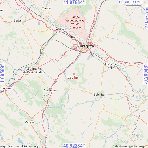
Jaulín GPS coordinates[2]
41° 27' 7.128" North, 0° 59' 33.216" West
| Map corner | latitude | longitude |
|---|---|---|
| Upper-left | 41.97684°, | -1.69569° |
| Center: | 41.45198°, | -0.99256° |
| Lower-right: | 40.92284°, | -0.28943° |
| Map W x H: | 117.2×117.2 km | = 72.8×72.8mi |
| max Lat: | 43.74134° ⇑40.4% North |
| Jaulín: | 41.45198° |
| min Lat: | ⇓59.6% South 27.64134° |
| min Long | Jaulín | max Long |
| -18.00367° | -0.99256° | 4.2899° |
| W 77.3%⇐ | ⇒22.7% E |
Elevation
Elevation of Jaulín is 513 m = 1683 ft, and this is 85 m = 279 ft below average elevation for this country.
| Max E: |
1682 m = 5518 ft | 61% |
| Avg. | 598 m = 1962 ft | |
| Jaulín | 513 m = 1683 ft | |
Min E: |
0 m = 0 ft | 39% |
See also: Spain elevation on elevation.city.
Geographical zone
Jaulín is located in North temperate zone (between Tropic of Cancer and the Arctic Circle). Distance of this Northern Tropic circle is 2003.1 km =1244.7 mi to South.| Distance of | km | miles | from Jaulín |
|---|---|---|---|
| North Pole | 5398 | 3354.2 | to North |
| Arctic Circle | 2792.1 | 1734.9 | to North |
| Tropic Cancer | 2003.1 | 1244.7 | to South |
| Equator | 4609 | 2863.9 | to South |


Nearby cities:
15 places around Jaulín: (largest is in red/bold)
• Aguilón
18.1 km =11.2 mi,  194°
194°
• Botorrita
6.9 km =4.3 mi,  332°
332°
• Cadrete
11.8 km =7.3 mi,  13°
13°
• Cuarte de Huerva
16.6 km =10.3 mi,  17°
17°
• Fuendetodos
12.5 km =7.8 mi,  167°
167°
• Longares
15.7 km =9.8 mi,  249°
249°
• María de Huerva
9.7 km =6 mi,  358°
358°
• Mezalocha
8.1 km =5 mi, 248°
• Montecanal
20.3 km =12.6 mi, 12°
• Mozota
7.2 km =4.5 mi,  299°
299°
• Muel
7.9 km =4.9 mi,  281°
281°
• Puebla de Albortón
13.6 km =8.5 mi,  123°
123°
• Tosos
16.6 km =10.3 mi,  203°
203°
• Valmadrid
9 km =5.6 mi,  95°
95°
• Villanueva del Huerva
11.6 km =7.2 mi, 198°
Sources, notices
• [Note1] Compared only with cities in Spain existing in our database
• [Src1] Map data: © OpenStreetMap contributors (CC-BY-SA)
• [Src2] Other city data from geonames.org with taken over terms of usage.
• [Src3] Geographical zone / Annual Mean Temperature by Robert A. Rohde @ Wikipedia
