Valmadrid geodata
Valmadrid (Aragon) is a seat of a third-order administrative division; located in Spain in Europe/Madrid (GMT+2) time zone. With population of 102 people, there are 5908 cities with bigger population in this country. Compared to other cities in Spain, 59.3% of cities are located further ↓South; 78.1% of cities are located further ←West and 60% of cities have higher elevation than Valmadrid. Note1


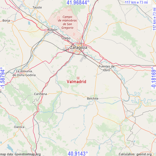
Valmadrid GPS coordinates[2]
41° 26' 36.636" North, 0° 53' 5.352" West
| Map corner | latitude | longitude |
|---|---|---|
| Upper-left | 41.96844°, | -1.58794° |
| Center: | 41.44351°, | -0.88482° |
| Lower-right: | 40.9143°, | -0.18169° |
| Map W x H: | 117.2×117.2 km | = 72.8×72.8mi |
| max Lat: | 43.74134° ⇑40.7% North |
| Valmadrid: | 41.44351° |
| min Lat: | ⇓59.3% South 27.64134° |
| min Long | Valmadrid | max Long |
| -18.00367° | -0.88482° | 4.2899° |
| W 78.1%⇐ | ⇒21.9% E |
Elevation
Elevation of Valmadrid is 526 m = 1726 ft, and this is 72 m = 236 ft below average elevation for this country.
| Max E: |
1682 m = 5518 ft | 60% |
| Avg. | 598 m = 1962 ft | |
| Valmadrid | 526 m = 1726 ft | |
Min E: |
0 m = 0 ft | 40% |
See also: Spain elevation on elevation.city.
Geographical zone
Valmadrid is located in North temperate zone (between Tropic of Cancer and the Arctic Circle). Distance of this Northern Tropic circle is 2002.2 km =1244.1 mi to South.| Distance of | km | miles | from Valmadrid |
|---|---|---|---|
| North Pole | 5399 | 3354.8 | to North |
| Arctic Circle | 2793.1 | 1735.6 | to North |
| Tropic Cancer | 2002.2 | 1244.1 | to South |
| Equator | 4608.1 | 2863.3 | to South |


Nearby cities:
15 places around Valmadrid: (largest is in red/bold)
• Almonacid de la Cuba
19.7 km =12.2 mi,  156°
156°
• Belchite
18.8 km =11.7 mi,  144°
144°
• Botorrita
14.1 km =8.8 mi,  300°
300°
• Cadrete
14 km =8.7 mi,  333°
333°
• Cuarte de Huerva
17.3 km =10.7 mi,  346°
346°
• El Burgo de Ebro
18.6 km =11.6 mi,  40°
40°
• Fuendetodos
12.9 km =8 mi,  209°
209°
• Jaulín
9 km =5.6 mi,  275°
275°
• María de Huerva
14.1 km =8.8 mi,  318°
318°
• Mediana
15.1 km =9.4 mi,  80°
80°
• Mezalocha
16.6 km =10.3 mi,  263°
263°
• Mozota
15.9 km =9.9 mi,  286°
286°
• Muel
16.9 km =10.5 mi, 278°
• Puebla de Albortón
6.9 km =4.3 mi, 159°
• Villanueva del Huerva
16.1 km =10 mi,  231°
231°
Sources, notices
• [Note1] Compared only with cities in Spain existing in our database
• [Src1] Map data: © OpenStreetMap contributors (CC-BY-SA)
• [Src2] Other city data from geonames.org with taken over terms of usage.
• [Src3] Geographical zone / Annual Mean Temperature by Robert A. Rohde @ Wikipedia
