Fresno El Viejo geodata
Fresno El Viejo (Castille and León) is a populated place; located in Spain in Europe/Madrid (GMT+2) time zone. With population of 1,168 people, there are 2754 cities with bigger population in this country. Compared to other cities in Spain, 53.1% of cities are located further ↓South; 74.3% of cities are located further →East and 62.3% of cities have lower elevation than Fresno El Viejo. Note1
Administrative division(s):
- Level 1: Castille and León
- Level 2: Provincia de Valladolid
- Level 3: Fresno el Viejo


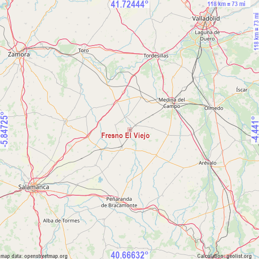
Fresno El Viejo GPS coordinates[2]
41° 11' 51.072" North, 5° 8' 38.868" West
| Map corner | latitude | longitude |
|---|---|---|
| Upper-left | 41.72444°, | -5.84725° |
| Center: | 41.19752°, | -5.14413° |
| Lower-right: | 40.66632°, | -4.441° |
| Map W x H: | 117.7×117.7 km | = 73.1×73.1mi |
| max Lat: | 43.74134° ⇑46.9% North |
| Fresno El Viejo: | 41.19752° |
| min Lat: | ⇓53.1% South 27.64134° |
| min Long | Fresno El Viejo | max Long |
| -18.00367° | -5.14413° | 4.2899° |
| W 25.7%⇐ | ⇒74.3% E |
Elevation
Elevation of Fresno El Viejo is 759 m = 2490 ft, and this is 161 m = 528 ft above average elevation for this country.
| Max E: |
1682 m = 5518 ft | 37.7% |
| Fresno El Viejo | 759 m 2490 ft | |
| Avg. | 598 m = 1962 ft | |
Min E: |
0 m = 0 ft | 62.3% |
See also: Spain elevation on elevation.city.
Geographical zone
Fresno El Viejo is located in North temperate zone (between Tropic of Cancer and the Arctic Circle). Distance of this Northern Tropic circle is 1974.8 km =1227.1 mi to South.| Distance of | km | miles | from Fresno El Viejo |
|---|---|---|---|
| North Pole | 5426.3 | 3371.7 | to North |
| Arctic Circle | 2820.4 | 1752.5 | to North |
| Tropic Cancer | 1974.8 | 1227.1 | to South |
| Equator | 4580.7 | 2846.3 | to South |


Nearby cities:
15 places around Fresno El Viejo: (largest is in red/bold)
• Alaejos
13.6 km =8.5 mi,  333°
333°
• Bobadilla del Campo
10.2 km =6.3 mi,  85°
85°
• Cantalapiedra
8.6 km =5.3 mi,  202°
202°
• Carpio
3.4 km =2.1 mi,  59°
59°
• Castrillo de la Guareña
15.6 km =9.7 mi,  283°
283°
• Cervillego de la Cruz
16.3 km =10.1 mi, 93°
• Horcajo de las Torres
15.4 km =9.6 mi,  163°
163°
• Nava del Rey
15.7 km =9.8 mi,  19°
19°
• Nueva Villa de las Torres
10.7 km =6.6 mi,  43°
43°
• Palaciosrubios
16.7 km =10.4 mi,  194°
194°
• Tarazona de Guareña
9.3 km =5.8 mi,  252°
252°
• Torrecilla de la Orden
7.1 km =4.4 mi,  289°
289°
• Velascálvaro
14.8 km =9.2 mi,  75°
75°
• Villaflores
14.7 km =9.1 mi,  210°
210°
• Villaverde de Medina
15.7 km =9.8 mi, 39°
Sources, notices
• [Note1] Compared only with cities in Spain existing in our database
• [Src1] Map data: © OpenStreetMap contributors (CC-BY-SA)
• [Src2] Other city data from geonames.org with taken over terms of usage.
• [Src3] Geographical zone / Annual Mean Temperature by Robert A. Rohde @ Wikipedia
