Bugedo geodata
Bugedo (Castille and León) is a seat of a third-order administrative division; located in Spain in Europe/Madrid (GMT+2) time zone. With population of 150 people, there are 5428 cities with bigger population in this country. Compared to other cities in Spain, 90.6% of cities are located further ↓South; 54.1% of cities are located further ←West and 59.3% of cities have higher elevation than Bugedo. Note1


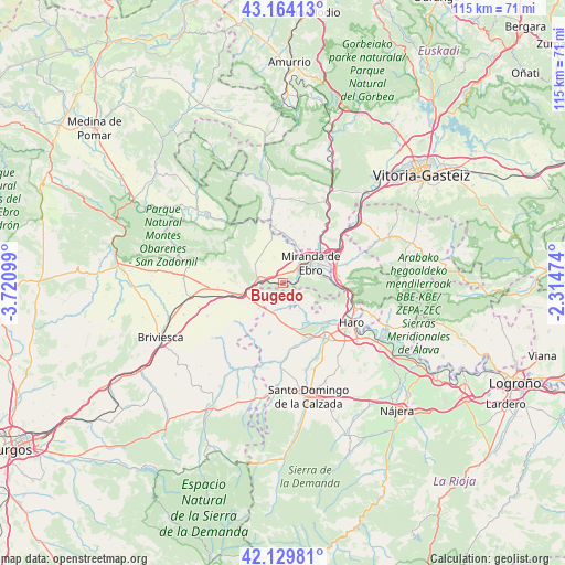
Bugedo GPS coordinates[2]
42° 38' 56.832" North, 3° 1' 4.296" West
| Map corner | latitude | longitude |
|---|---|---|
| Upper-left | 43.16413°, | -3.72099° |
| Center: | 42.64912°, | -3.01786° |
| Lower-right: | 42.12981°, | -2.31474° |
| Map W x H: | 115×115 km | = 71.5×71.5mi |
| max Lat: | 43.74134° ⇑9.4% North |
| Bugedo: | 42.64912° |
| min Lat: | ⇓90.6% South 27.64134° |
| min Long | Bugedo | max Long |
| -18.00367° | -3.01786° | 4.2899° |
| W 54.1%⇐ | ⇒45.9% E |
Elevation
Elevation of Bugedo is 537 m = 1762 ft, and this is 61 m = 200 ft below average elevation for this country.
| Max E: |
1682 m = 5518 ft | 59.3% |
| Avg. | 598 m = 1962 ft | |
| Bugedo | 537 m = 1762 ft | |
Min E: |
0 m = 0 ft | 40.7% |
See also: Spain elevation on elevation.city.
Geographical zone
Bugedo is located in North temperate zone (between Tropic of Cancer and the Arctic Circle). Distance of this Northern Tropic circle is 2136.2 km =1327.4 mi to South.| Distance of | km | miles | from Bugedo |
|---|---|---|---|
| North Pole | 5264.9 | 3271.5 | to North |
| Arctic Circle | 2659 | 1652.2 | to North |
| Tropic Cancer | 2136.2 | 1327.4 | to South |
| Equator | 4742.1 | 2946.6 | to South |


Nearby cities:
15 places around Bugedo: (largest is in red/bold)
• Altable
7.1 km =4.4 mi,  223°
223°
• Ameyugo
3.7 km =2.3 mi,  282°
282°
• Cellorigo
2.9 km =1.8 mi,  149°
149°
• Encío
6.1 km =3.8 mi,  293°
293°
• Foncea
4.1 km =2.5 mi,  204°
204°
• Fonzaleche
7.6 km =4.7 mi,  176°
176°
• Galbárruli
5.6 km =3.5 mi,  123°
123°
• Miranda de Ebro
7.1 km =4.4 mi,  54°
54°
• Pancorbo
7.9 km =4.9 mi,  257°
257°
• Sajazarra
8.1 km =5 mi, 145°
• Santa Gadea del Cid
8.1 km =5 mi,  335°
335°
• Treviana
10.4 km =6.5 mi,  194°
194°
• Villalba de Rioja
11.6 km =7.2 mi,  112°
112°
• Villanueva de Teba
11.9 km =7.4 mi,  269°
269°
• Zambrana
11.4 km =7.1 mi,  83°
83°
Sources, notices
• [Note1] Compared only with cities in Spain existing in our database
• [Src1] Map data: © OpenStreetMap contributors (CC-BY-SA)
• [Src2] Other city data from geonames.org with taken over terms of usage.
• [Src3] Geographical zone / Annual Mean Temperature by Robert A. Rohde @ Wikipedia
