Fayón geodata
Fayón (Aragon) is a seat of a third-order administrative division; located in Spain in Europe/Madrid (GMT+2) time zone. With population of 404 people, there are 4129 cities with bigger population in this country. Compared to other cities in Spain, 54.2% of cities are located further ↓South; 88.4% of cities are located further ←West and 81.5% of cities have higher elevation than Fayón. Note1


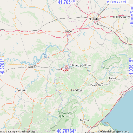
Fayón GPS coordinates[2]
41° 14' 18.636" North, 0° 19' 58.872" East
| Map corner | latitude | longitude |
|---|---|---|
| Upper-left | 41.7651°, | -0.3701° |
| Center: | 41.23851°, | 0.33302° |
| Lower-right: | 40.70764°, | 1.03615° |
| Map W x H: | 117.6×117.6 km | = 73.1×73.1mi |
| max Lat: | 43.74134° ⇑45.8% North |
| Fayón: | 41.23851° |
| min Lat: | ⇓54.2% South 27.64134° |
| min Long | Fayón | max Long |
| -18.00367° | 0.33302° | 4.2899° |
| W 88.4%⇐ | ⇒11.6% E |
Elevation
Elevation of Fayón is 196 m = 643 ft, and this is 402 m = 1319 ft below average elevation for this country.
| Max E: |
1682 m = 5518 ft | 81.5% |
| Avg. | 598 m = 1962 ft | |
| Fayón | 196 m = 643 ft | |
Min E: |
0 m = 0 ft | 18.5% |
See also: Spain elevation on elevation.city.
Geographical zone
Fayón is located in North temperate zone (between Tropic of Cancer and the Arctic Circle). Distance of this Northern Tropic circle is 1979.4 km =1229.9 mi to South.| Distance of | km | miles | from Fayón |
|---|---|---|---|
| North Pole | 5421.8 | 3368.9 | to North |
| Arctic Circle | 2815.9 | 1749.7 | to North |
| Tropic Cancer | 1979.4 | 1229.9 | to South |
| Equator | 4585.3 | 2849.2 | to South |


Nearby cities:
15 places around Fayón: (largest is in red/bold)
• Ascó
20.5 km =12.7 mi,  107°
107°
• Batea
16.1 km =10 mi,  186°
186°
• Fabara
15.3 km =9.5 mi,  243°
243°
• Flix
18.2 km =11.3 mi,  92°
92°
• Gandesa
22.4 km =13.9 mi,  156°
156°
• Llardecáns
23.6 km =14.7 mi,  50°
50°
• Maella
20.7 km =12.9 mi,  231°
231°
• Maials
19.9 km =12.4 mi,  44°
44°
• Mequinensa / Mequinenza
15.1 km =9.4 mi,  350°
350°
• Nonaspe
7.9 km =4.9 mi,  245°
245°
• Vilalba dels Arcs
15.2 km =9.4 mi,  152°
152°
• Vinebre
22.3 km =13.9 mi, 105°
• la Fatarella
14.9 km =9.3 mi,  122°
122°
• la Granja d'Escarp
20 km =12.4 mi,  8°
8°
• la Pobla de Massaluca
6.3 km =3.9 mi,  166°
166°
Sources, notices
• [Note1] Compared only with cities in Spain existing in our database
• [Src1] Map data: © OpenStreetMap contributors (CC-BY-SA)
• [Src2] Other city data from geonames.org with taken over terms of usage.
• [Src3] Geographical zone / Annual Mean Temperature by Robert A. Rohde @ Wikipedia
