Maella geodata
Maella (Aragon) is a seat of a third-order administrative division; located in Spain in Europe/Madrid (GMT+2) time zone. With population of 1,995 people, there are 2170 cities with bigger population in this country. Compared to other cities in Spain, 51.5% of cities are located further ↓South; 87.7% of cities are located further ←West and 74.6% of cities have higher elevation than Maella. Note1


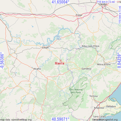
Maella GPS coordinates[2]
41° 7' 21.036" North, 0° 8' 21.336" East
| Map corner | latitude | longitude |
|---|---|---|
| Upper-left | 41.65004°, | -0.56386° |
| Center: | 41.12251°, | 0.13926° |
| Lower-right: | 40.59071°, | 0.84239° |
| Map W x H: | 117.8×117.8 km | = 73.2×73.2mi |
| max Lat: | 43.74134° ⇑48.5% North |
| Maella: | 41.12251° |
| min Lat: | ⇓51.5% South 27.64134° |
| min Long | Maella | max Long |
| -18.00367° | 0.13926° | 4.2899° |
| W 87.7%⇐ | ⇒12.3% E |
Elevation
Elevation of Maella is 302 m = 991 ft, and this is 296 m = 971 ft below average elevation for this country.
| Max E: |
1682 m = 5518 ft | 74.6% |
| Avg. | 598 m = 1962 ft | |
| Maella | 302 m = 991 ft | |
Min E: |
0 m = 0 ft | 25.4% |
See also: Spain elevation on elevation.city.
Geographical zone
Maella is located in North temperate zone (between Tropic of Cancer and the Arctic Circle). Distance of this Northern Tropic circle is 1966.5 km =1221.9 mi to South.| Distance of | km | miles | from Maella |
|---|---|---|---|
| North Pole | 5434.7 | 3377 | to North |
| Arctic Circle | 2828.8 | 1757.7 | to North |
| Tropic Cancer | 1966.5 | 1221.9 | to South |
| Equator | 4572.4 | 2841.2 | to South |


Nearby cities:
15 places around Maella: (largest is in red/bold)
• Arenys de Lledó / Arens de Lledó
18.2 km =11.3 mi,  142°
142°
• Batea
14.7 km =9.1 mi,  102°
102°
• Calaceite
12.5 km =7.8 mi,  160°
160°
• Caseres
13.6 km =8.5 mi, 136°
• Caspe
19.4 km =12.1 mi,  309°
309°
• Fabara
6.6 km =4.1 mi,  22°
22°
• Fayón
20.7 km =12.9 mi,  51°
51°
• Lledó
21.9 km =13.6 mi,  148°
148°
• Mazaleón
8.6 km =5.3 mi,  200°
200°
• Nonaspe
13.2 km =8.2 mi,  43°
43°
• Torre del Compte
20.9 km =13 mi,  186°
186°
• Valdealgorfa
20.7 km =12.9 mi,  224°
224°
• Valdeltormo
15.8 km =9.8 mi, 197°
• Valjunquera
21.2 km =13.2 mi,  206°
206°
• la Pobla de Massaluca
18.9 km =11.7 mi,  69°
69°
Sources, notices
• [Note1] Compared only with cities in Spain existing in our database
• [Src1] Map data: © OpenStreetMap contributors (CC-BY-SA)
• [Src2] Other city data from geonames.org with taken over terms of usage.
• [Src3] Geographical zone / Annual Mean Temperature by Robert A. Rohde @ Wikipedia
