Lanaja geodata
Lanaja (Aragon) is a seat of a third-order administrative division; located in Spain in Europe/Madrid (GMT+2) time zone. With population of 1,465 people, there are 2491 cities with bigger population in this country. Compared to other cities in Spain, 67.9% of cities are located further ↓South; 84.2% of cities are located further ←West and 70.9% of cities have higher elevation than Lanaja. Note1


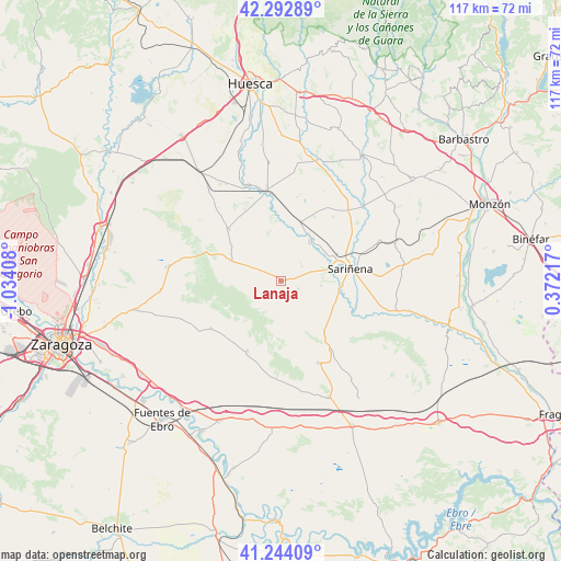
Lanaja GPS coordinates[2]
41° 46' 14.268" North, 0° 19' 51.42" West
| Map corner | latitude | longitude |
|---|---|---|
| Upper-left | 42.29289°, | -1.03408° |
| Center: | 41.77063°, | -0.33095° |
| Lower-right: | 41.24409°, | 0.37217° |
| Map W x H: | 116.6×116.6 km | = 72.5×72.5mi |
| max Lat: | 43.74134° ⇑32.1% North |
| Lanaja: | 41.77063° |
| min Lat: | ⇓67.9% South 27.64134° |
| min Long | Lanaja | max Long |
| -18.00367° | -0.33095° | 4.2899° |
| W 84.2%⇐ | ⇒15.8% E |
Elevation
Elevation of Lanaja is 369 m = 1211 ft, and this is 229 m = 751 ft below average elevation for this country.
| Max E: |
1682 m = 5518 ft | 70.9% |
| Avg. | 598 m = 1962 ft | |
| Lanaja | 369 m = 1211 ft | |
Min E: |
0 m = 0 ft | 29.1% |
See also: Spain elevation on elevation.city.
Geographical zone
Lanaja is located in North temperate zone (between Tropic of Cancer and the Arctic Circle). Distance of this Northern Tropic circle is 2038.5 km =1266.7 mi to South.| Distance of | km | miles | from Lanaja |
|---|---|---|---|
| North Pole | 5362.6 | 3332.2 | to North |
| Arctic Circle | 2756.7 | 1712.9 | to North |
| Tropic Cancer | 2038.5 | 1266.7 | to South |
| Equator | 4644.5 | 2886 | to South |


Nearby cities:
15 places around Lanaja: (largest is in red/bold)
• Albalatillo
15.4 km =9.6 mi,  104°
104°
• Alberuela de Tubo
18.1 km =11.2 mi,  32°
32°
• Alcubierre
10.9 km =6.8 mi,  292°
292°
• Almuniente
21 km =13 mi,  341°
341°
• Capdesaso
14.6 km =9.1 mi,  56°
56°
• Castejón de Monegros
18.6 km =11.6 mi,  156°
156°
• Farlete
17.7 km =11 mi,  235°
235°
• Grañén
19.2 km =11.9 mi,  350°
350°
• Huerto
22.4 km =13.9 mi,  37°
37°
• Lalueza
9.9 km =6.2 mi, 39°
• Monegrillo
16.3 km =10.1 mi,  205°
205°
• Poleñino
11.2 km =7 mi,  8°
8°
• Robres
15.2 km =9.4 mi,  314°
314°
• Sariñena
14.5 km =9 mi,  80°
80°
• Senés de Alcubierre
20.1 km =12.5 mi,  319°
319°
Sources, notices
• [Note1] Compared only with cities in Spain existing in our database
• [Src1] Map data: © OpenStreetMap contributors (CC-BY-SA)
• [Src2] Other city data from geonames.org with taken over terms of usage.
• [Src3] Geographical zone / Annual Mean Temperature by Robert A. Rohde @ Wikipedia
