Esplús geodata
Esplús (Aragon) is a seat of a third-order administrative division; located in Spain in Europe/Madrid (GMT+2) time zone. With population of 734 people, there are 3339 cities with bigger population in this country. Compared to other cities in Spain, 68.5% of cities are located further ↓South; 88.2% of cities are located further ←West and 76.6% of cities have higher elevation than Esplús. Note1


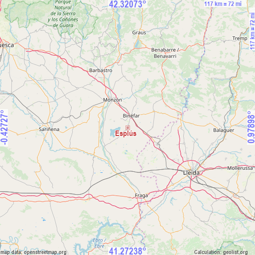
Esplús GPS coordinates[2]
41° 47' 55.32" North, 0° 16' 33.096" East
| Map corner | latitude | longitude |
|---|---|---|
| Upper-left | 42.32073°, | -0.42727° |
| Center: | 41.7987°, | 0.27586° |
| Lower-right: | 41.27238°, | 0.97898° |
| Map W x H: | 116.6×116.6 km | = 72.5×72.5mi |
| max Lat: | 43.74134° ⇑31.5% North |
| Esplús: | 41.7987° |
| min Lat: | ⇓68.5% South 27.64134° |
| min Long | Esplús | max Long |
| -18.00367° | 0.27586° | 4.2899° |
| W 88.2%⇐ | ⇒11.8% E |
Elevation
Elevation of Esplús is 277 m = 909 ft, and this is 321 m = 1053 ft below average elevation for this country.
| Max E: |
1682 m = 5518 ft | 76.6% |
| Avg. | 598 m = 1962 ft | |
| Esplús | 277 m = 909 ft | |
Min E: |
0 m = 0 ft | 23.4% |
See also: Spain elevation on elevation.city.
Geographical zone
Esplús is located in North temperate zone (between Tropic of Cancer and the Arctic Circle). Distance of this Northern Tropic circle is 2041.7 km =1268.7 mi to South.| Distance of | km | miles | from Esplús |
|---|---|---|---|
| North Pole | 5359.5 | 3330.2 | to North |
| Arctic Circle | 2753.6 | 1711 | to North |
| Tropic Cancer | 2041.7 | 1268.7 | to South |
| Equator | 4647.6 | 2887.9 | to South |


Nearby cities:
15 places around Esplús: (largest is in red/bold)
• Albalate de Cinca
13.1 km =8.1 mi,  231°
231°
• Albelda
17 km =10.6 mi,  64°
64°
• Alcolea de Cinca
15.8 km =9.8 mi,  236°
236°
• Alfántega
11.1 km =6.9 mi,  287°
287°
• Almacelles
15.3 km =9.5 mi,  118°
118°
• Belver de Cinca
14.3 km =8.9 mi,  214°
214°
• Binaced
6.9 km =4.3 mi,  295°
295°
• Binéfar
6.1 km =3.8 mi,  14°
14°
• Chalamera
17.5 km =10.9 mi, 212°
• Monzón
14.2 km =8.8 mi,  331°
331°
• Osso de Cinca
16.3 km =10.1 mi, 205°
• Pueyo de Santa Cruz
11.9 km =7.4 mi, 303°
• San Esteban de Litera (Sant Esteve de Llitera)
12.6 km =7.8 mi,  19°
19°
• Tamarit de Llitera / Tamarite de Litera
14.4 km =8.9 mi, 57°
• el Torricó / Altorricon
11.5 km =7.1 mi,  87°
87°
Sources, notices
• [Note1] Compared only with cities in Spain existing in our database
• [Src1] Map data: © OpenStreetMap contributors (CC-BY-SA)
• [Src2] Other city data from geonames.org with taken over terms of usage.
• [Src3] Geographical zone / Annual Mean Temperature by Robert A. Rohde @ Wikipedia
