el Torricó / Altorricon geodata
el Torricó / Altorricon (Aragon) is a populated place; located in Spain in Europe/Madrid (GMT+2) time zone. With population of 1,462 people, there are 2495 cities with bigger population in this country. Compared to other cities in Spain, 68.6% of cities are located further ↓South; 88.6% of cities are located further ←West and 77.6% of cities have higher elevation than el Torricó / Altorricon. Note1
Administrative division(s):
- Level 1: Aragon
- Level 2: Provincia de Huesca
- Level 3: Tamarite de Litera
Current local time in el Torricó / Altorricon:
10:47 PM, ThursdayDifference from your time zone: hours


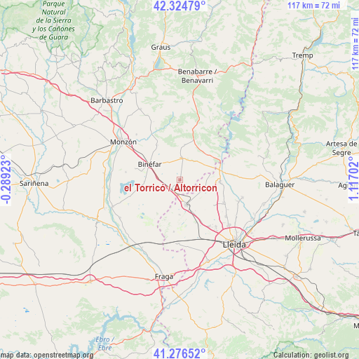
el Torricó / Altorricon GPS coordinates[2]
41° 48' 10.08" North, 0° 24' 50.04" East
| Map corner | latitude | longitude |
|---|---|---|
| Upper-left | 42.32479°, | -0.28923° |
| Center: | 41.8028°, | 0.4139° |
| Lower-right: | 41.27652°, | 1.11702° |
| Map W x H: | 116.6×116.6 km | = 72.5×72.5mi |
| max Lat: | 43.74134° ⇑31.4% North |
| el Torricó / Altorricon: | 41.8028° |
| min Lat: | ⇓68.6% South 27.64134° |
| min Long | el Torricó / A | max Long |
| -18.00367° | 0.4139° | 4.2899° |
| W 88.6%⇐ | ⇒11.4% E |
Elevation
Elevation of el Torricó / Altorricon is 262 m = 860 ft, and this is 336 m = 1102 ft below average elevation for this country.
| Max E: |
1682 m = 5518 ft | 77.6% |
| Avg. | 598 m = 1962 ft | |
| el Torricó / Altorricon | 262 m = 860 ft | |
Min E: |
0 m = 0 ft | 22.4% |
See also: Spain elevation on elevation.city.
Geographical zone
el Torricó / Altorricon is located in North temperate zone (between Tropic of Cancer and the Arctic Circle). Distance of this Northern Tropic circle is 2042.1 km =1268.9 mi to South.| Distance of | km | miles | from el Torricó / Altorricon |
|---|---|---|---|
| North Pole | 5359 | 3329.9 | to North |
| Arctic Circle | 2753.1 | 1710.7 | to North |
| Tropic Cancer | 2042.1 | 1268.9 | to South |
| Equator | 4648 | 2888.1 | to South |


Nearby cities:
15 places around el Torricó / Altorricon: (largest is in red/bold)
• Albelda
7.9 km =4.9 mi,  28°
28°
• Alfarràs
14.1 km =8.8 mi,  83°
83°
• Algerri
18.5 km =11.5 mi,  85°
85°
• Alguaire
15.9 km =9.9 mi,  117°
117°
• Almacelles
8.1 km =5 mi,  166°
166°
• Almenar
12.8 km =8 mi, 93°
• Alpicat
19.3 km =12 mi,  142°
142°
• Baells
17.2 km =10.7 mi,  12°
12°
• Binaced
17.8 km =11.1 mi,  278°
278°
• Binéfar
11.3 km =7 mi,  298°
298°
• Esplús
11.5 km =7.1 mi,  267°
267°
• San Esteban de Litera (Sant Esteve de Llitera)
13.4 km =8.3 mi,  327°
327°
• Tamarit de Llitera / Tamarite de Litera
7.4 km =4.6 mi, 5°
• Vilanova de Segrià
19.4 km =12.1 mi, 119°
• el Campell / Alcampell
11.6 km =7.2 mi, 7°
Sources, notices
• [Note1] Compared only with cities in Spain existing in our database
• [Src1] Map data: © OpenStreetMap contributors (CC-BY-SA)
• [Src2] Other city data from geonames.org with taken over terms of usage.
• [Src3] Geographical zone / Annual Mean Temperature by Robert A. Rohde @ Wikipedia
