Encinedo geodata
Encinedo (Castille and León) is a seat of a third-order administrative division; located in Spain in Europe/Madrid (GMT+2) time zone. With population of 949 people, there are 3013 cities with bigger population in this country. Compared to other cities in Spain, 81.2% of cities are located further ↓South; 91.9% of cities are located further →East and 86.7% of cities have lower elevation than Encinedo. Note1


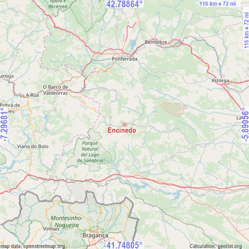
Encinedo GPS coordinates[2]
42° 16' 13.764" North, 6° 35' 37.248" West
| Map corner | latitude | longitude |
|---|---|---|
| Upper-left | 42.78864°, | -7.29681° |
| Center: | 42.27049°, | -6.59368° |
| Lower-right: | 41.74805°, | -5.89056° |
| Map W x H: | 115.7×115.7 km | = 71.9×71.9mi |
| max Lat: | 43.74134° ⇑18.8% North |
| Encinedo: | 42.27049° |
| min Lat: | ⇓81.2% South 27.64134° |
| min Long | Encinedo | max Long |
| -18.00367° | -6.59368° | 4.2899° |
| W 8.1%⇐ | ⇒91.9% E |
Elevation
Elevation of Encinedo is 976 m = 3202 ft, and this is 378 m = 1240 ft above average elevation for this country.
| Max E: |
1682 m = 5518 ft | 13.3% |
| Encinedo | 976 m 3202 ft | |
| Avg. | 598 m = 1962 ft | |
Min E: |
0 m = 0 ft | 86.7% |
See also: Spain elevation on elevation.city.
Geographical zone
Encinedo is located in North temperate zone (between Tropic of Cancer and the Arctic Circle). Distance of this Northern Tropic circle is 2094.1 km =1301.2 mi to South.| Distance of | km | miles | from Encinedo |
|---|---|---|---|
| North Pole | 5307 | 3297.6 | to North |
| Arctic Circle | 2701.1 | 1678.4 | to North |
| Tropic Cancer | 2094.1 | 1301.2 | to South |
| Equator | 4700 | 2920.4 | to South |


Nearby cities:
15 places around Encinedo: (largest is in red/bold)
• Asturianos
25.8 km =16 mi,  160°
160°
• Benuza
17.2 km =10.7 mi,  326°
326°
• Borrenes
26.7 km =16.6 mi,  336°
336°
• Castrillo de Cabrera
8.8 km =5.5 mi,  27°
27°
• Cobreros
23.6 km =14.7 mi,  201°
201°
• Espadañedo
23.8 km =14.8 mi,  136°
136°
• Galende
19.3 km =12 mi, 197°
• Muelas de los Caballeros
26.4 km =16.4 mi,  126°
126°
• Palacios de Sanabria
24.2 km =15 mi,  166°
166°
• Puebla de Sanabria
24.3 km =15.1 mi,  187°
187°
• Puente de Domingo Flórez
24.4 km =15.2 mi,  310°
310°
• Robleda-Cervantes
20.9 km =13 mi,  180°
180°
• San Justo
15.5 km =9.6 mi, 189°
• Trefacio
17.3 km =10.7 mi, 196°
• Truchas
13 km =8.1 mi,  94°
94°
Sources, notices
• [Note1] Compared only with cities in Spain existing in our database
• [Src1] Map data: © OpenStreetMap contributors (CC-BY-SA)
• [Src2] Other city data from geonames.org with taken over terms of usage.
• [Src3] Geographical zone / Annual Mean Temperature by Robert A. Rohde @ Wikipedia
