Galende geodata
Galende (Castille and León) is a seat of a third-order administrative division; located in Spain in Europe/Madrid (GMT+2) time zone. With population of 1,336 people, there are 2607 cities with bigger population in this country. Compared to other cities in Spain, 76.6% of cities are located further ↓South; 92.5% of cities are located further →East and 86% of cities have lower elevation than Galende. Note1
Administrative division(s):
- Level 1: Castille and León
- Level 2: Provincia de Zamora
- Level 3: Galende


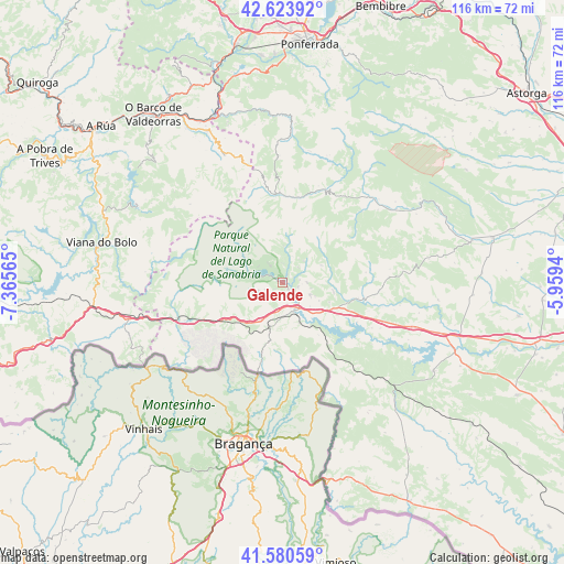
Galende GPS coordinates[2]
42° 6' 15.84" North, 6° 39' 45.072" West
| Map corner | latitude | longitude |
|---|---|---|
| Upper-left | 42.62392°, | -7.36565° |
| Center: | 42.1044°, | -6.66252° |
| Lower-right: | 41.58059°, | -5.9594° |
| Map W x H: | 116×116 km | = 72.1×72.1mi |
| max Lat: | 43.74134° ⇑23.4% North |
| Galende: | 42.1044° |
| min Lat: | ⇓76.6% South 27.64134° |
| min Long | Galende | max Long |
| -18.00367° | -6.66252° | 4.2899° |
| W 7.5%⇐ | ⇒92.5% E |
Elevation
Elevation of Galende is 964 m = 3163 ft, and this is 366 m = 1201 ft above average elevation for this country.
| Max E: |
1682 m = 5518 ft | 14% |
| Galende | 964 m 3163 ft | |
| Avg. | 598 m = 1962 ft | |
Min E: |
0 m = 0 ft | 86% |
See also: Spain elevation on elevation.city.
Geographical zone
Galende is located in North temperate zone (between Tropic of Cancer and the Arctic Circle). Distance of this Northern Tropic circle is 2075.7 km =1289.8 mi to South.| Distance of | km | miles | from Galende |
|---|---|---|---|
| North Pole | 5325.5 | 3309.1 | to North |
| Arctic Circle | 2719.6 | 1689.9 | to North |
| Tropic Cancer | 2075.7 | 1289.8 | to South |
| Equator | 4681.6 | 2909 | to South |


Nearby cities:
15 places around Galende: (largest is in red/bold)
• Asturianos
15.4 km =9.6 mi,  112°
112°
• Cernadilla
22.3 km =13.9 mi, 114°
• Cobreros
4.7 km =2.9 mi,  222°
222°
• Encinedo
19.3 km =12 mi,  17°
17°
• Espadañedo
22.2 km =13.8 mi,  86°
86°
• Lubián
21.5 km =13.4 mi,  249°
249°
• Manzanal de Arriba
22.2 km =13.8 mi,  124°
124°
• Manzanal de los Infantes
23.7 km =14.7 mi,  103°
103°
• Palacios de Sanabria
12.5 km =7.8 mi, 113°
• Porto
20.7 km =12.9 mi,  289°
289°
• Puebla de Sanabria
6.1 km =3.8 mi,  156°
156°
• Requejo
10.5 km =6.5 mi, 218°
• Robleda-Cervantes
6.1 km =3.8 mi, 113°
• San Justo
4.5 km =2.8 mi,  44°
44°
• Trefacio
2 km =1.2 mi, 19°
Sources, notices
• [Note1] Compared only with cities in Spain existing in our database
• [Src1] Map data: © OpenStreetMap contributors (CC-BY-SA)
• [Src2] Other city data from geonames.org with taken over terms of usage.
• [Src3] Geographical zone / Annual Mean Temperature by Robert A. Rohde @ Wikipedia
