Collsuspina geodata
Collsuspina (Catalonia) is a seat of a third-order administrative division; located in Spain in Europe/Madrid (GMT+2) time zone. With population of 308 people, there are 4472 cities with bigger population in this country. Compared to other cities in Spain, 69.2% of cities are located further ↓South; 94.9% of cities are located further ←West and 80.7% of cities have lower elevation than Collsuspina. Note1


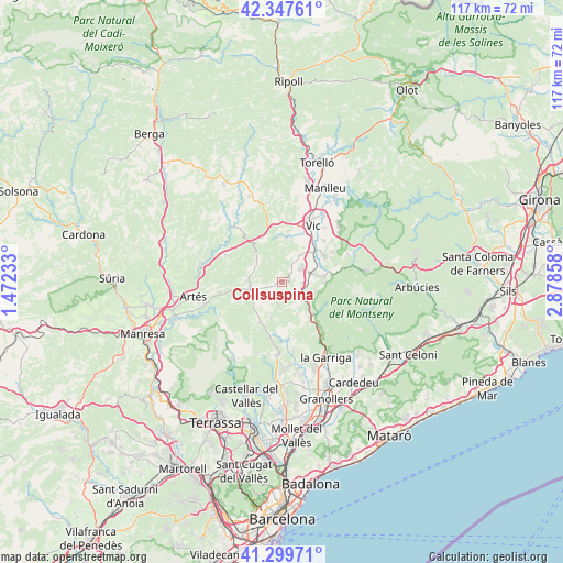
Collsuspina GPS coordinates[2]
41° 49' 32.88" North, 2° 10' 31.656" East
| Map corner | latitude | longitude |
|---|---|---|
| Upper-left | 42.34761°, | 1.47233° |
| Center: | 41.8258°, | 2.17546° |
| Lower-right: | 41.29971°, | 2.87858° |
| Map W x H: | 116.5×116.5 km | = 72.4×72.4mi |
| max Lat: | 43.74134° ⇑30.8% North |
| Collsuspina: | 41.8258° |
| min Lat: | ⇓69.2% South 27.64134° |
| min Long | Collsuspina | max Long |
| -18.00367° | 2.17546° | 4.2899° |
| W 94.9%⇐ | ⇒5.1% E |
Elevation
Elevation of Collsuspina is 903 m = 2963 ft, and this is 305 m = 1001 ft above average elevation for this country.
| Max E: |
1682 m = 5518 ft | 19.3% |
| Collsuspina | 903 m 2963 ft | |
| Avg. | 598 m = 1962 ft | |
Min E: |
0 m = 0 ft | 80.7% |
See also: Spain elevation on elevation.city.
Geographical zone
Collsuspina is located in North temperate zone (between Tropic of Cancer and the Arctic Circle). Distance of this Northern Tropic circle is 2044.7 km =1270.5 mi to South.| Distance of | km | miles | from Collsuspina |
|---|---|---|---|
| North Pole | 5356.5 | 3328.4 | to North |
| Arctic Circle | 2750.6 | 1709.1 | to North |
| Tropic Cancer | 2044.7 | 1270.5 | to South |
| Equator | 4650.6 | 2889.7 | to South |


Nearby cities:
15 places around Collsuspina: (largest is in red/bold)
• Aiguafreda
8.9 km =5.5 mi,  135°
135°
• Castellcir
7.3 km =4.5 mi,  189°
189°
• Castellterçol
9.7 km =6 mi,  210°
210°
• Centelles
4.8 km =3 mi,  131°
131°
• Moià
6.6 km =4.1 mi,  255°
255°
• Muntanyola
6.4 km =4 mi,  5°
5°
• Sant Martí de Centelles
7.1 km =4.4 mi,  159°
159°
• Sant Quirze Safaja
10.5 km =6.5 mi, 191°
• Santa Eugènia de Berga
12.2 km =7.6 mi,  47°
47°
• Santa Eulàlia de Riuprimer
9.5 km =5.9 mi, 6°
• Santa Maria d'Oló
12.6 km =7.8 mi,  291°
291°
• Seva
8.8 km =5.5 mi,  80°
80°
• Tagamanent
12.4 km =7.7 mi, 142°
• Taradell
10.7 km =6.6 mi,  59°
59°
• Tona
5 km =3.1 mi, 60°
Sources, notices
• [Note1] Compared only with cities in Spain existing in our database
• [Src1] Map data: © OpenStreetMap contributors (CC-BY-SA)
• [Src2] Other city data from geonames.org with taken over terms of usage.
• [Src3] Geographical zone / Annual Mean Temperature by Robert A. Rohde @ Wikipedia
