Aiguafreda geodata
Aiguafreda (Catalonia) is a populated place; located in Spain in Europe/Madrid (GMT+2) time zone. With population of 2,308 people, there are 1995 cities with bigger population in this country. Compared to other cities in Spain, 67.8% of cities are located further ↓South; 95.6% of cities are located further ←West and 68.4% of cities have higher elevation than Aiguafreda. Note1


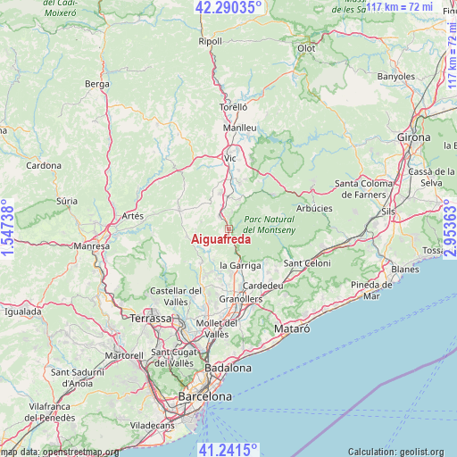
Aiguafreda GPS coordinates[2]
41° 46' 5.052" North, 2° 15' 1.836" East
| Map corner | latitude | longitude |
|---|---|---|
| Upper-left | 42.29035°, | 1.54738° |
| Center: | 41.76807°, | 2.25051° |
| Lower-right: | 41.2415°, | 2.95363° |
| Map W x H: | 116.6×116.6 km | = 72.5×72.5mi |
| max Lat: | 43.74134° ⇑32.2% North |
| Aiguafreda: | 41.76807° |
| min Lat: | ⇓67.8% South 27.64134° |
| min Long | Aiguafreda | max Long |
| -18.00367° | 2.25051° | 4.2899° |
| W 95.6%⇐ | ⇒4.4% E |
Elevation
Elevation of Aiguafreda is 409 m = 1342 ft, and this is 189 m = 620 ft below average elevation for this country.
| Max E: |
1682 m = 5518 ft | 68.4% |
| Avg. | 598 m = 1962 ft | |
| Aiguafreda | 409 m = 1342 ft | |
Min E: |
0 m = 0 ft | 31.6% |
See also: Spain elevation on elevation.city.
Geographical zone
Aiguafreda is located in North temperate zone (between Tropic of Cancer and the Arctic Circle). Distance of this Northern Tropic circle is 2038.3 km =1266.5 mi to South.| Distance of | km | miles | from Aiguafreda |
|---|---|---|---|
| North Pole | 5362.9 | 3332.4 | to North |
| Arctic Circle | 2757 | 1713.1 | to North |
| Tropic Cancer | 2038.3 | 1266.5 | to South |
| Equator | 4644.2 | 2885.8 | to South |


Nearby cities:
15 places around Aiguafreda: (largest is in red/bold)
• Bigues i Riells
9.5 km =5.9 mi,  188°
188°
• Castellcir
7.4 km =4.6 mi,  263°
263°
• Castellterçol
11.3 km =7 mi, 259°
• Centelles
4.2 km =2.6 mi,  321°
321°
• Collsuspina
8.9 km =5.5 mi, 315°
• Figaró
5.5 km =3.4 mi,  160°
160°
• L'Ametlla del Vallès
11.4 km =7.1 mi,  173°
173°
• Sant Feliu de Codines
10.3 km =6.4 mi,  222°
222°
• Sant Martí de Centelles
3.7 km =2.3 mi,  266°
266°
• Sant Quirze Safaja
9.2 km =5.7 mi,  245°
245°
• Seva
8.2 km =5.1 mi,  17°
17°
• Tagamanent
3.7 km =2.3 mi, 157°
• Taradell
12.3 km =7.6 mi,  14°
14°
• Tona
9.1 km =5.7 mi,  348°
348°
• la Garriga
9.8 km =6.1 mi, 163°
Sources, notices
• [Note1] Compared only with cities in Spain existing in our database
• [Src1] Map data: © OpenStreetMap contributors (CC-BY-SA)
• [Src2] Other city data from geonames.org with taken over terms of usage.
• [Src3] Geographical zone / Annual Mean Temperature by Robert A. Rohde @ Wikipedia
