Centelles geodata
Centelles (Catalonia) is a populated place; located in Spain in Europe/Madrid (GMT+2) time zone. With population of 6,493 people, there are 1086 cities with bigger population in this country. Compared to other cities in Spain, 68.4% of cities are located further ↓South; 95.5% of cities are located further ←West and 59.6% of cities have higher elevation than Centelles. Note1


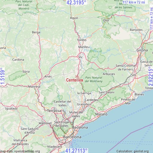
Centelles GPS coordinates[2]
41° 47' 50.856" North, 2° 13' 8.472" East
| Map corner | latitude | longitude |
|---|---|---|
| Upper-left | 42.3195°, | 1.5159° |
| Center: | 41.79746°, | 2.21902° |
| Lower-right: | 41.27113°, | 2.92215° |
| Map W x H: | 116.6×116.6 km | = 72.5×72.5mi |
| max Lat: | 43.74134° ⇑31.6% North |
| Centelles: | 41.79746° |
| min Lat: | ⇓68.4% South 27.64134° |
| min Long | Centelles | max Long |
| -18.00367° | 2.21902° | 4.2899° |
| W 95.5%⇐ | ⇒4.5% E |
Elevation
Elevation of Centelles is 532 m = 1745 ft, and this is 66 m = 217 ft below average elevation for this country.
| Max E: |
1682 m = 5518 ft | 59.6% |
| Avg. | 598 m = 1962 ft | |
| Centelles | 532 m = 1745 ft | |
Min E: |
0 m = 0 ft | 40.4% |
See also: Spain elevation on elevation.city.
Geographical zone
Centelles is located in North temperate zone (between Tropic of Cancer and the Arctic Circle). Distance of this Northern Tropic circle is 2041.5 km =1268.5 mi to South.| Distance of | km | miles | from Centelles |
|---|---|---|---|
| North Pole | 5359.6 | 3330.3 | to North |
| Arctic Circle | 2753.7 | 1711.1 | to North |
| Tropic Cancer | 2041.5 | 1268.5 | to South |
| Equator | 4647.4 | 2887.8 | to South |


Nearby cities:
15 places around Centelles: (largest is in red/bold)
• Aiguafreda
4.2 km =2.6 mi,  141°
141°
• Castellcir
6.3 km =3.9 mi,  229°
229°
• Castellterçol
10 km =6.2 mi,  238°
238°
• Collsuspina
4.8 km =3 mi,  311°
311°
• Figaró
9.6 km =6 mi,  152°
152°
• Moià
10.1 km =6.3 mi,  278°
278°
• Muntanyola
10 km =6.2 mi,  342°
342°
• Sant Feliu de Codines
11.7 km =7.3 mi,  201°
201°
• Sant Martí de Centelles
3.7 km =2.3 mi, 197°
• Sant Quirze Safaja
9.1 km =5.7 mi,  218°
218°
• Santa Eugènia de Berga
12.6 km =7.8 mi,  25°
25°
• Seva
6.8 km =4.2 mi,  48°
48°
• Tagamanent
7.8 km =4.8 mi, 149°
• Taradell
10.3 km =6.4 mi, 33°
• Tona
5.7 km =3.5 mi,  7°
7°
Sources, notices
• [Note1] Compared only with cities in Spain existing in our database
• [Src1] Map data: © OpenStreetMap contributors (CC-BY-SA)
• [Src2] Other city data from geonames.org with taken over terms of usage.
• [Src3] Geographical zone / Annual Mean Temperature by Robert A. Rohde @ Wikipedia
