Santurdejo geodata
Santurdejo (La Rioja) is a seat of a third-order administrative division; located in Spain in Europe/Madrid (GMT+2) time zone. With population of 177 people, there are 5203 cities with bigger population in this country. Compared to other cities in Spain, 84.1% of cities are located further ↓South; 55.2% of cities are located further ←West and 65.9% of cities have lower elevation than Santurdejo. Note1


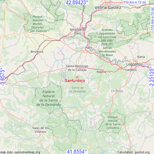
Santurdejo GPS coordinates[2]
42° 22' 37.056" North, 2° 57' 15.732" West
| Map corner | latitude | longitude |
|---|---|---|
| Upper-left | 42.89423°, | -3.6575° |
| Center: | 42.37696°, | -2.95437° |
| Lower-right: | 41.8554°, | -2.25125° |
| Map W x H: | 115.5×115.5 km | = 71.8×71.8mi |
| max Lat: | 43.74134° ⇑15.9% North |
| Santurdejo: | 42.37696° |
| min Lat: | ⇓84.1% South 27.64134° |
| min Long | Santurdejo | max Long |
| -18.00367° | -2.95437° | 4.2899° |
| W 55.2%⇐ | ⇒44.8% E |
Elevation
Elevation of Santurdejo is 784 m = 2572 ft, and this is 186 m = 610 ft above average elevation for this country.
| Max E: |
1682 m = 5518 ft | 34.1% |
| Santurdejo | 784 m 2572 ft | |
| Avg. | 598 m = 1962 ft | |
Min E: |
0 m = 0 ft | 65.9% |
See also: Spain elevation on elevation.city.
Geographical zone
Santurdejo is located in North temperate zone (between Tropic of Cancer and the Arctic Circle). Distance of this Northern Tropic circle is 2106 km =1308.6 mi to South.| Distance of | km | miles | from Santurdejo |
|---|---|---|---|
| North Pole | 5295.2 | 3290.3 | to North |
| Arctic Circle | 2689.3 | 1671.1 | to North |
| Tropic Cancer | 2106 | 1308.6 | to South |
| Equator | 4711.9 | 2927.8 | to South |


Nearby cities:
15 places around Santurdejo: (largest is in red/bold)
• Berceo
9.4 km =5.8 mi,  116°
116°
• Canillas de Río Tuerto
9.6 km =6 mi,  74°
74°
• Cañas
9 km =5.6 mi,  79°
79°
• Cirueña
6.2 km =3.9 mi,  50°
50°
• Corporales
7 km =4.3 mi,  331°
331°
• Ezcaray
7.5 km =4.7 mi,  220°
220°
• Hervías
9.6 km =6 mi,  35°
35°
• Manzanares de Rioja
5.3 km =3.3 mi, 66°
• Ojacastro
5.3 km =3.3 mi,  231°
231°
• Pazuengos
7 km =4.3 mi,  160°
160°
• San Millán de la Cogolla
9.2 km =5.7 mi, 124°
• Santo Domingo de la Calzada
7 km =4.3 mi,  0°
0°
• Villar de Torre
7.4 km =4.6 mi,  94°
94°
• Villarejo
5.5 km =3.4 mi, 93°
• Zorraquín
9 km =5.6 mi, 230°
Sources, notices
• [Note1] Compared only with cities in Spain existing in our database
• [Src1] Map data: © OpenStreetMap contributors (CC-BY-SA)
• [Src2] Other city data from geonames.org with taken over terms of usage.
• [Src3] Geographical zone / Annual Mean Temperature by Robert A. Rohde @ Wikipedia
